IMAGES TAKEN NEAR TO
Woodbridge Road, WOODBRIDGE, IP13 9LS
Introduction
This page details the photographs taken nearby to Woodbridge Road, IP13 9LS by members of the Geograph project.
The Geograph project started in 2005 with the aim of publishing, organising and preserving representative images for every square kilometre of Great Britain, Ireland and the Isle of Man.

There are currently over 7.5m images from over14,400 individuals and you can help contribute to the project by visiting https://www.geograph.org.uk
Image Map
Images are licensed for reuse under creativecommons.org/licenses/by-sa/2.0
Notes
- Clicking on the map will re-center to the selected point.
- The higher the marker number, the further away the image location is from the centre of the postcode.
Image Listing (18 Images Found)
Images are licensed for reuse under creativecommons.org/licenses/by-sa/2.0
Image
Details
Distance
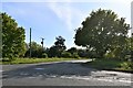
3
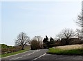
Parham: Where Dark Lane joins Woodbridge Road
Image: © Michael Garlick
Taken: 8 May 2020
0.07 miles
4
Parham: Where Dark Lane joins Woodbridge Road
Image: © Michael Garlick
Taken: 8 May 2020
0.07 miles
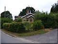
5

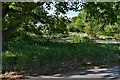
Broadwaters Gatehouse
A former crossing keeper's cottage. The railway line was dismantled before the Beeching Cuts. In 1952 passenger trains were discontinued and in 1965 the goods trains stopped running. See also http://www.geograph.org.uk/photo/1964780
Image: © Adrian S Pye
Taken: 8 Feb 2011
0.09 miles
6
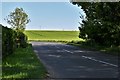
The former level-crossing-keeper's cottage
On Dark Lane at the junction with the B1116 Woodbridge Road
Also see Image
Image: © Geographer
Taken: 13 Jul 2010
0.10 miles
7
Former crossing-keeper's cottage
This was once the site of a level crossing on the Wickham Market to Framlingham branch line, which closed to passengers (school specials excepted) in 1952 and to goods in 1965. The wing on the right is a modern addition.
Image: © John Sutton
Taken: 14 Jul 2010
0.11 miles

9
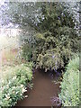
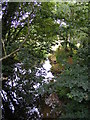
River Ore under the B1116 Woodbridge Road Bridge
Image: © Geographer
Taken: 13 Jul 2010
0.13 miles