IMAGES TAKEN NEAR TO
Oak Corner, WOODBRIDGE, IP13 7BQ
Introduction
This page details the photographs taken nearby to Oak Corner, IP13 7BQ by members of the Geograph project.
The Geograph project started in 2005 with the aim of publishing, organising and preserving representative images for every square kilometre of Great Britain, Ireland and the Isle of Man.

There are currently over 7.5m images from over14,400 individuals and you can help contribute to the project by visiting https://www.geograph.org.uk
Image Map
Images are licensed for reuse under creativecommons.org/licenses/by-sa/2.0
Notes
- Clicking on the map will re-center to the selected point.
- The higher the marker number, the further away the image location is from the centre of the postcode.
Image Listing (89 Images Found)
Images are licensed for reuse under creativecommons.org/licenses/by-sa/2.0
Image
Details
Distance
1
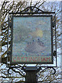
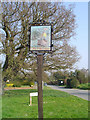
Cretingham Village sign (detail) the west face
The sign is in the form of a coarse mosaic. The front of the sign shows a Viking long-ship with all on board waving axes and swords in the air and a man on the river bank calling to them “I’m over here!”. We must assume they were welcome because on the reverse one of them is hoeing the soil while his wife drops seeds into the drill. At least that is what I see, whether it is what was intended is debatable. The other side https://www.geograph.org.uk/photo/4374141
The official version can be read here https://www.geograph.org.uk/photo/6780705
Image: © Adrian S Pye
Taken: 7 Mar 2015
0.01 miles
2
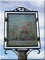
Cretingham Village sign (detail) the east face
The sign is in the form of a coarse mosaic. We must assume they were welcome and settled in the area because on this side one of them is hoeing the soil while his wife drops seeds into the drill. The other side of the sign shows a Viking long-ship with all on board waving axes and swords in the air and a man on the river bank calling to them “I’m over here!”. https://www.geograph.org.uk/photo/4374145
The official version can be read here https://www.geograph.org.uk/photo/6780705
Image: © Adrian S Pye
Taken: 7 Mar 2015
0.01 miles
3
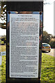
Cretingham village sign (explanation)
The mosaics are not easy to distinguish especially in sunlight but the village has thoughtfully attached this explanation of the sign so the viewer can make sense of the pictures. https://www.geograph.org.uk/photo/4374145 https://www.geograph.org.uk/photo/4374141
Image: © Adrian S Pye
Taken: 9 Mar 2021
0.01 miles
4
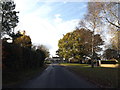
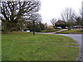
Brandeston Road, Cretingham
Looking towards The Street
Image: © Geographer
Taken: 21 Nov 2013
0.02 miles
5
Cretingham village sign
A Viking longship can just be discerned on the sign.
http://www.geograph.org.uk/photo/4374141 http://www.geograph.org.uk/photo/4374145
Image: © Adrian S Pye
Taken: 2 Apr 2007
0.03 miles
6
Cretingham Village Sign
On Brandeston Road at the junction with The Street
Image: © Geographer
Taken: 13 Jan 2009
0.03 miles
7

Cretingham Village Sign
On Brandeston Road at the junction with The Street
(Close up)
Image: © Geographer
Taken: 13 Jan 2009
0.03 miles
8

Cretingham Village Sign
On Brandeston Road at the junction with The Street
Image: © Geographer
Taken: 13 Jan 2009
0.03 miles
9

Brandeston Road, Cretingham
At the junction with The Street,near The Cretingham Bell Public House
Image: © Geographer
Taken: 13 Jan 2009
0.05 miles
10

The Cretingham Bell Public House
On The Street at the junction with Brandeston Road
Image: © Geographer
Taken: 13 Jan 2009
0.05 miles