IMAGES TAKEN NEAR TO
Dallinghoo, WOODBRIDGE, IP13 0JX
Introduction
This page details the photographs taken nearby to IP13 0JX by members of the Geograph project.
The Geograph project started in 2005 with the aim of publishing, organising and preserving representative images for every square kilometre of Great Britain, Ireland and the Isle of Man.

There are currently over 7.5m images from over14,400 individuals and you can help contribute to the project by visiting https://www.geograph.org.uk
Image Map
Images are licensed for reuse under creativecommons.org/licenses/by-sa/2.0
Notes
- Clicking on the map will re-center to the selected point.
- The higher the marker number, the further away the image location is from the centre of the postcode.
Image Listing (39 Images Found)
Images are licensed for reuse under creativecommons.org/licenses/by-sa/2.0
Image
Details
Distance
1
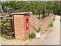
Post Office Dallinghoo Postbox
On Church Road
Postbox No.IP13 6276
Image: © Geographer
Taken: 11 Apr 2011
0.01 miles
2
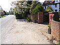
Church Road & Post Office Dallinghoo Postbox
Postbox No.IP13 6276
Image: © Geographer
Taken: 11 Apr 2011
0.02 miles
3
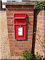
Post Office Dallinghoo Postbox
On Church Road
Postbox No.IP13 6276
Image: © Geographer
Taken: 11 Apr 2011
0.02 miles
4
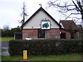
Footpath off Church Road
Near Dallinghoo Village Hall
Image: © Geographer
Taken: 11 Apr 2011
0.02 miles
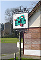
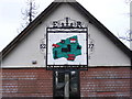
7
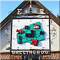
Dallinghoo village sign
Erected outside the village hall for the Queen’s silver jubilee in 1977, the sign at Dallinghoo is in the form of a map, with features in their (more or less) correct location. The church of St Mary, with its red brick top to the tower, is near the village centre. Immediately below is Dallinghoo Hall, continuing clockwise are electricity pylons which skirt the village to the south, Highgate Farm house, the old school house, Whitehouse Farm and Robin’s Nest. https://www.geograph.org.uk/photo/4291805
Image: © Adrian S Pye
Taken: 15 Feb 2021
0.03 miles
8
Dallinghoo village sign
Erected outside the village hall for the Queen’s silver jubilee in 1977, the sign at Dallinghoo is in the form of a map, with features in their (more or less) correct location. The church of St Mary, with its red brick top to the tower, is near the village centre. Immediately below is Dallinghoo Hall, continuing clockwise are electricity pylons which skirt the village to the south, Highgate Farm house, the old school house, Whitehouse Farm and Robin’s Nest. https://www.geograph.org.uk/photo/6760232
Image: © Adrian S Pye
Taken: 9 May 2007
0.03 miles
9
Dallinghoo Village Sign
Off Pound Hill
(Close up)
Image: © Geographer
Taken: 19 Jan 2009
0.03 miles