IMAGES TAKEN NEAR TO
The Street, WOODBRIDGE, IP13 0HU
Introduction
This page details the photographs taken nearby to The Street, IP13 0HU by members of the Geograph project.
The Geograph project started in 2005 with the aim of publishing, organising and preserving representative images for every square kilometre of Great Britain, Ireland and the Isle of Man.

There are currently over 7.5m images from over14,400 individuals and you can help contribute to the project by visiting https://www.geograph.org.uk
Image Map
Images are licensed for reuse under creativecommons.org/licenses/by-sa/2.0
Notes
- Clicking on the map will re-center to the selected point.
- The higher the marker number, the further away the image location is from the centre of the postcode.
Image Listing (79 Images Found)
Images are licensed for reuse under creativecommons.org/licenses/by-sa/2.0
Image
Details
Distance
2
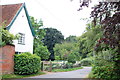
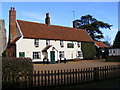
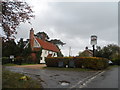
'The Greyhound Inn' at Pettistree
This is an old grade 2 listed timber-framed building with many of the timbers exposed at the rear of the building. There is a suggestion that it might have been a priest's house or used by another important village person as it is a building where Manor Courts were held in the 18th century and also inquests in the 19th century. The 15th century tower of the parish church can be seen on the left of the picture.
Image: © Robert Edwards
Taken: 5 Feb 2007
0.06 miles
3
Cut Mark Pettistree Clock House
Cut Mark Pettistree Clock House C wall, SE face.
Image: © Cud05
Taken: 9 Feb 2018
0.07 miles
4
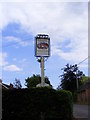
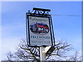
The Greyhound Inn sign
On The Street at the junction with Walnuts Lane
Image: © Geographer
Taken: 19 May 2011
0.08 miles
5
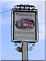
The Greyhound Inn Sign, Pettistree
On The Street at the junction with Walnuts Lane
Image: © Geographer
Taken: 19 Jan 2009
0.08 miles
6
The Greyhound Inn sign
On The Street at the junction with Walnuts Lane
Image: © Geographer
Taken: 19 May 2011
0.09 miles
7
Greyhound Inn, Pettistree
On The Street at the junction with Walnuts Lane
Image: © Geographer
Taken: 19 Jan 2009
0.09 miles
8
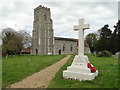
Pettistree War Memorial beside the church path
The perfect location for a War Memorial.
The Memorial bears the nine names of the men lost during the Great War and that of one man lost in the Second World War.
Image: © Adrian S Pye
Taken: 30 Apr 2015
0.09 miles
9
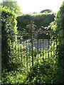
Disused churchyard gate in Pettistree village
For a view of the church see > http://www.geograph.org.uk/photo/1880808.
Image: © Evelyn Simak
Taken: 23 May 2010
0.09 miles
10
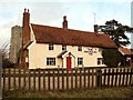
The Greyhound pub, Pettistree
Originally built in C16 as a dwelling, perhaps a priest's house. See http://www.britishlistedbuildings.co.uk/en-286535-the-greyhound-pettistree-suffolk#.VpbXUPmLTIU for entry in British Listed Buildings.
Image: © Bikeboy
Taken: 29 Oct 2015
0.09 miles