IMAGES TAKEN NEAR TO
Hall Road, WOODBRIDGE, IP13 0AX
Introduction
This page details the photographs taken nearby to Hall Road, IP13 0AX by members of the Geograph project.
The Geograph project started in 2005 with the aim of publishing, organising and preserving representative images for every square kilometre of Great Britain, Ireland and the Isle of Man.

There are currently over 7.5m images from over14,400 individuals and you can help contribute to the project by visiting https://www.geograph.org.uk
Image Map
Images are licensed for reuse under creativecommons.org/licenses/by-sa/2.0
Notes
- Clicking on the map will re-center to the selected point.
- The higher the marker number, the further away the image location is from the centre of the postcode.
Image Listing (61 Images Found)
Images are licensed for reuse under creativecommons.org/licenses/by-sa/2.0
Image
Details
Distance
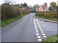
1
Hall Road, Marlesford
Looking towards the junction with Low Road
Image: © Geographer
Taken: 28 Feb 2009
0.01 miles
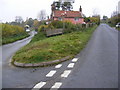
2
Hall Road, Marlesford
Looking towards Parham at the junction with Low Road
Road No.C241
Image: © Geographer
Taken: 5 Nov 2008
0.03 miles
4
Marlesford Village Sign
On Hall Road at the junction with Low Road
(Close up)
Image: © Geographer
Taken: 5 Nov 2008
0.03 miles
5
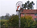
Marlesford Village Sign
On Hall Road at the junction with Low Road
Image: © Geographer
Taken: 5 Nov 2008
0.03 miles
6
Marlesford Village Sign
On Hall Road at the junction with Low Road
Road No.C241
Image: © Geographer
Taken: 5 Nov 2008
0.03 miles
7
Hall Road, Marlesford
Looking towards Sandy Lane at the junction with Low Road
Road No.C241
Image: © Geographer
Taken: 5 Nov 2008
0.04 miles
8
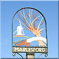
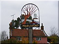
Marlesford village sign
Marlesford village sign depicts the old post mill which once stood in Mill Lane. The bridge over the River Ore, (represented by the wavy blue line at the bottom) is representative of the old bridge on the A12 before it was replaced by the much stronger flat bridge. The ford, from which Marlesford takes its name is still not bridged, except by a footbridge. The tree which appears to be a pollarded willow is probably included because there were, at one time in the past, a number of them along the river bank. https://www.geograph.org.uk/photo/4293460
Image: © Adrian S Pye
Taken: 9 Mar 2021
0.04 miles
9
Marlesford village sign
Marlesford village sign depicts the old post mill which once stood in Mill Lane. The bridge over the River Ore, (represented by the wavy blue line at the bottom) is representative of the old bridge on the A12 before it was replaced by the much stronger flat bridge. The ford, from which Marlesford takes its name is still not bridged, except by a footbridge. The tree which appears to be a pollarded willow is probably included because there were, at one time in the past, a number of them along the river bank. https://www.geograph.org.uk/photo/6779913
Image: © Adrian S Pye
Taken: 28 Feb 2007
0.04 miles