IMAGES TAKEN NEAR TO
Cliff Road, WOODBRIDGE, IP12 4QL
Introduction
This page details the photographs taken nearby to Cliff Road, IP12 4QL by members of the Geograph project.
The Geograph project started in 2005 with the aim of publishing, organising and preserving representative images for every square kilometre of Great Britain, Ireland and the Isle of Man.

There are currently over 7.5m images from over14,400 individuals and you can help contribute to the project by visiting https://www.geograph.org.uk
Image Map
Images are licensed for reuse under creativecommons.org/licenses/by-sa/2.0
Notes
- Clicking on the map will re-center to the selected point.
- The higher the marker number, the further away the image location is from the centre of the postcode.
Image Listing (180 Images Found)
Images are licensed for reuse under creativecommons.org/licenses/by-sa/2.0
Image
Details
Distance
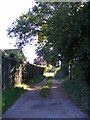
1
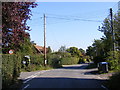
Cliff Road, Waldringfield
At the junction with Sandy Lane
Image: © Geographer
Taken: 30 Sep 2011
0.01 miles
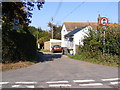
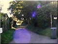
2
Cliff Road, Waldringfield
Looking towards Sandy Lane
Image: © Geographer
Taken: 30 Sep 2011
0.01 miles
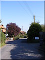
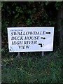
3
Sandy Lane, Waldringfield
At the junction with Cliff Road
Image: © Geographer
Taken: 30 Sep 2011
0.01 miles
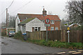
4
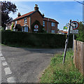
Waldringfield: at the corner of Cliff Road and Sandy Lane
The house, built in 1903, has a story. The pale blotches in the brickwork at first-floor level on the front of the house are where pock-marks caused by shrapnel from a wartime bomb were filled.
Image: © John Sutton
Taken: 22 Aug 2018
0.01 miles
9
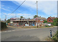
Waldringfield: building at the corner of Sandy Lane
Image] shows what was here before.
Image: © John Sutton
Taken: 7 Aug 2022
0.02 miles
10
Waldringfield: the corner of Sandy Lane
This was formerly the village post office. For the 2016 arrangements, see Image
Image: © John Sutton
Taken: 30 Dec 2016
0.03 miles