IMAGES TAKEN NEAR TO
The Street, WOODBRIDGE, IP12 3PU
Introduction
This page details the photographs taken nearby to The Street, IP12 3PU by members of the Geograph project.
The Geograph project started in 2005 with the aim of publishing, organising and preserving representative images for every square kilometre of Great Britain, Ireland and the Isle of Man.

There are currently over 7.5m images from over14,400 individuals and you can help contribute to the project by visiting https://www.geograph.org.uk
Image Map
Images are licensed for reuse under creativecommons.org/licenses/by-sa/2.0
Notes
- Clicking on the map will re-center to the selected point.
- The higher the marker number, the further away the image location is from the centre of the postcode.
Image Listing (39 Images Found)
Images are licensed for reuse under creativecommons.org/licenses/by-sa/2.0
Image
Details
Distance
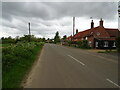
1
Chillesford - B1084 Main Road through Village
Image: © James Emmans
Taken: 16 Dec 2016
0.02 miles
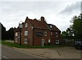
2
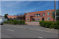
Meadow View, Chillesford
Recently constructed, and looking out on Image
Image: © Peter Facey
Taken: 6 Jun 2014
0.03 miles
4
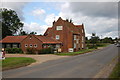
The Froize, Chillesford
From their website it seems the owners are uncertain of the derivation and meaning of the name of the restaurant.
Image: © Trevor Harris
Taken: 21 Jul 2012
0.04 miles
6
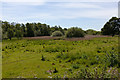
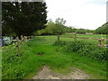
Meadow, Chillesford
This is the meadow viewed by Image
Image: © Peter Facey
Taken: 6 Jun 2014
0.05 miles
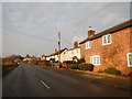
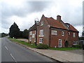
7
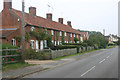
Chillesford
Taken looking east along the B1084. Chillesford comprises a few houses and cottages such as these set out along this road.
Image: © David Kemp
Taken: 11 Sep 2014
0.07 miles