IMAGES TAKEN NEAR TO
Crag Farm Road, WOODBRIDGE, IP12 2BN
Introduction
This page details the photographs taken nearby to Crag Farm Road, IP12 2BN by members of the Geograph project.
The Geograph project started in 2005 with the aim of publishing, organising and preserving representative images for every square kilometre of Great Britain, Ireland and the Isle of Man.

There are currently over 7.5m images from over14,400 individuals and you can help contribute to the project by visiting https://www.geograph.org.uk
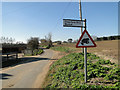
Image Map
Images are licensed for reuse under creativecommons.org/licenses/by-sa/2.0
Notes
- Clicking on the map will re-center to the selected point.
- The higher the marker number, the further away the image location is from the centre of the postcode.
Image Listing (13 Images Found)
Images are licensed for reuse under creativecommons.org/licenses/by-sa/2.0
Image
Details
Distance
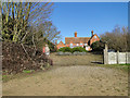
1
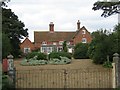
Crag Farmhouse
This imposing farmhouse has fantastic views over Sudbourne Marshes.
Image: © Alison Rawson
Taken: 1 Sep 2007
0.11 miles
2
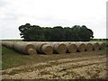
All rolled up!
Long lines of straw bales lined up in front of Chaplin's Carr.
Image: © Alison Rawson
Taken: 1 Sep 2007
0.11 miles
5

One enormous garden hose
Industrial size for irrigating the fields. Near Sudbourne.
Image: © Oliver Dixon
Taken: 7 Jun 2006
0.14 miles
6
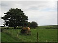
Job done!
This farm machinery sits in a field adjacent to Sudbourne Marshes.
Image: © Alison Rawson
Taken: 1 Sep 2007
0.16 miles
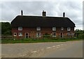
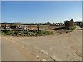
8
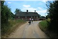
Crag Farm Cottages, Sudbourne
On the corner of Ferry Road and Crag Farm Road. Ferry Road is part of National Cycle Netwrok route 41 here.
Image: © Simon Mortimer
Taken: 24 Jul 2013
0.18 miles