IMAGES TAKEN NEAR TO
Marsh Lane, FELIXSTOWE, IP11 9RP
Introduction
This page details the photographs taken nearby to Marsh Lane, IP11 9RP by members of the Geograph project.
The Geograph project started in 2005 with the aim of publishing, organising and preserving representative images for every square kilometre of Great Britain, Ireland and the Isle of Man.

There are currently over 7.5m images from over14,400 individuals and you can help contribute to the project by visiting https://www.geograph.org.uk
Image Map
Images are licensed for reuse under creativecommons.org/licenses/by-sa/2.0
Notes
- Clicking on the map will re-center to the selected point.
- The higher the marker number, the further away the image location is from the centre of the postcode.
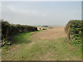
Image Listing (7 Images Found)
Images are licensed for reuse under creativecommons.org/licenses/by-sa/2.0
Image
Details
Distance
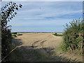
2
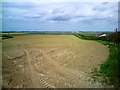
Farmland Beside Marsh Lane
Looking north-east towards the Deben, Kingsfleet to the extreme left of shot in the distance.
Image: © Tim Marchant
Taken: 5 May 2009
0.19 miles
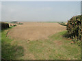
3
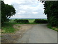
Around The Bend To Rues Farm
With views of Felixstowe Marshes and Rues Farm just around the corner this is the end of the public road near to Felixstowe Ferry Suffolk.
Image: © Keith Evans
Taken: 17 Jun 2007
0.19 miles
7
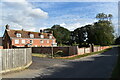
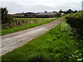
Fleet House, Marsh Lane, Felixstowe
Fleet House was formerly the farmhouse for Laurel Farm. It has also served as a girls boarding school, but is now a farmhouse once again.
Image: © Simon Mortimer
Taken: 22 Aug 2020
0.25 miles