IMAGES TAKEN NEAR TO
Kirton, IPSWICH, IP10 0QE
Introduction
This page details the photographs taken nearby to IP10 0QE by members of the Geograph project.
The Geograph project started in 2005 with the aim of publishing, organising and preserving representative images for every square kilometre of Great Britain, Ireland and the Isle of Man.

There are currently over 7.5m images from over14,400 individuals and you can help contribute to the project by visiting https://www.geograph.org.uk
Image Map
Images are licensed for reuse under creativecommons.org/licenses/by-sa/2.0
Notes
- Clicking on the map will re-center to the selected point.
- The higher the marker number, the further away the image location is from the centre of the postcode.
Image Listing (9 Images Found)
Images are licensed for reuse under creativecommons.org/licenses/by-sa/2.0
Image
Details
Distance
1
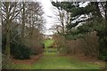
Kirton Lodge from the south
Kirton Lodge can be seen through the ride that cuts through woodlands in its landscaped grounds.
Image: © Simon Mortimer
Taken: 30 Dec 2011
0.01 miles
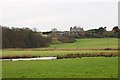
2
Kirton Lodge
Part of the Kirton Lodge farm complex near to Falkenham Suffolk.
Image: © Keith Evans
Taken: 13 Mar 2007
0.11 miles
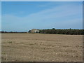
3
Farm buildings, part of a large complex at Kirton Lodge
Looking across a gridline.
Image: © Andrew Hill
Taken: 23 Jul 2008
0.12 miles
4
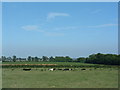
Cows taking things easy
I had always thought cows lying down was a sure indication of rainy weather on the way?
Image: © Alan Stewart
Taken: 31 May 2007
0.12 miles
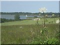
6
Track corner with view towards Kirton Creek and Deben River
Image: © Andrew Hill
Taken: 23 Jul 2008
0.21 miles
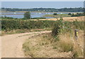
7
Sluice Farm, Kirton
Looking south across the valley of Kirton Brook, from the footpath between Hemley and Kirton Creek.
Image: © Simon Mortimer
Taken: 30 Dec 2011
0.23 miles
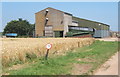
8
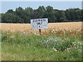
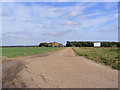
Sign by track to Kirton Lodge, with wheat field and woodland beyond
The woodland is called The Belt on 1:25,000 OS map.
Image: © Andrew Hill
Taken: 23 Jul 2008
0.24 miles
9
Footpath to Alder Carr & Entrance to Lodge Farm
Off Park Lane
Image: © Geographer
Taken: 10 Oct 2011
0.25 miles