IMAGES TAKEN NEAR TO
Stradbroke Grove, BUCKHURST HILL, IG9 5PF
Introduction
This page details the photographs taken nearby to Stradbroke Grove, IG9 5PF by members of the Geograph project.
The Geograph project started in 2005 with the aim of publishing, organising and preserving representative images for every square kilometre of Great Britain, Ireland and the Isle of Man.

There are currently over 7.5m images from over14,400 individuals and you can help contribute to the project by visiting https://www.geograph.org.uk
Image Map
Images are licensed for reuse under creativecommons.org/licenses/by-sa/2.0
Notes
- Clicking on the map will re-center to the selected point.
- The higher the marker number, the further away the image location is from the centre of the postcode.
Image Listing (30 Images Found)
Images are licensed for reuse under creativecommons.org/licenses/by-sa/2.0
Image
Details
Distance
4
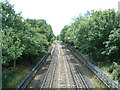
The Central Line looking south towards Buckhurst Hill
Halfway up the right side of the grid square. Taken from the footbridge over the Central Line (where it runs above ground), this was the worst part of my walk along section 19 of the London Loop, the bridge was grey, caged in overhead and covered with graffiti. Just as well I had a small lens as I had to poke it through the mesh.
Image: © Claire Ward
Taken: 20 Jul 2005
0.12 miles
5
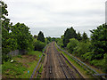
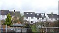
Central line north of Buckhurst Hill
It is curious that there appears to be the remains of a platform on the right, as the station was always entirely to the south of the road bridge.
Image: © Robin Webster
Taken: 2 Jun 2012
0.12 miles
6
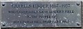
Linder's Seat
This seat in Image dedicated to businessman Charles Linder who left this Local Nature Reserve http://www.wildessex.net/sites/Linders%20Field.htm in trust for the people of Buckhurst Hill. See Image
Image: © Glyn Baker
Taken: 25 May 2017
0.14 miles
8
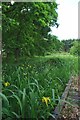
A Pond in Linder's Field
There was little water evident but the flag iris gave a splash of colour
Image: © Glyn Baker
Taken: 25 May 2017
0.14 miles

10
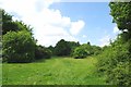
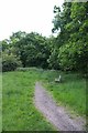
Linder's Field
Linders Field http://www.wildessex.net/sites/Linders%20Field.htm was left in trust to the people of Buckhurst Hill by buisnessman Charles Linder five years before his death in 1957. It is a Local Nature Reserve managed by Epping District Council with the help of Volunteers http://www.eppingforestdc.gov.uk/index.php/component/eventlist/venueevents/14-linder-s-field-local-nature-reserve. The shot is taken looking along one of the public footpaths that cross the reserve.
Image: © Glyn Baker
Taken: 25 May 2017
0.15 miles