
IMAGES TAKEN NEAR TO
The Drummonds, BUCKHURST HILL, IG9 5HG
Introduction
This page details the photographs taken nearby to The Drummonds, IG9 5HG by members of the Geograph project.
The Geograph project started in 2005 with the aim of publishing, organising and preserving representative images for every square kilometre of Great Britain, Ireland and the Isle of Man.

There are currently over 7.5m images from over14,400 individuals and you can help contribute to the project by visiting https://www.geograph.org.uk
Image Map
Images are licensed for reuse under creativecommons.org/licenses/by-sa/2.0
Notes
- Clicking on the map will re-center to the selected point.
- The higher the marker number, the further away the image location is from the centre of the postcode.
Image Listing (29 Images Found)
Images are licensed for reuse under creativecommons.org/licenses/by-sa/2.0
Image
Details
Distance
3
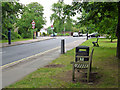
Benches on Queen's Road
Possible placed at the top of the hill up from the shops and the station for the less fit to recover.
Image: © Robin Webster
Taken: 2 Jun 2012
0.11 miles
4
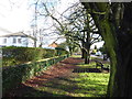
At the top of Queen's Road
High Road, Woodford Green is just behind where I am standing. Ahead Queen's Road drops down to Buckhurst Hill station and the Roding Valley.
Image: © Marathon
Taken: 7 Feb 2017
0.12 miles
5
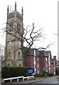
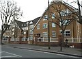
Buckhurst Hill: Former Congregational Church Tower
Not being a local I am a little mystified by this tower in Palmerston Road. It was certainly built as part of the Congregational Church in 1873, designed by the architect Edmond Egan. There is a photo dated 1923 in the Francis Frith collection http://www.francisfrith.com/search/england/essex/buckhurst+hill/photos/buckhurst+hill_73931.htm of the tower with the church behind, but searching via Google fails to reveal why the body of the church was subsequently demolished. Was it damaged by a bomb, was the building unsound, or were the maintenance costs too high? Today some 1980s flats have replaced the church and somewhat incongruously abut the tower on its eastern side, while the view of the four slender corner turrets is totally ruined by the festooned mobile phone masts...
Image: © Nigel Cox
Taken: 4 Jan 2008
0.12 miles
6
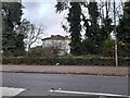
Tooley & Foster architects on High Road, Buckhurst Hill
Image: © David Howard
Taken: 21 Nov 2021
0.13 miles
7
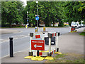
Pedestrian obstacles, High Road, Buckhurst Hill
The direction signs seem rather superfluous.
Image: © Robin Webster
Taken: 2 Jun 2012
0.13 miles
8

Pulpit Oak
With a girth of more than 4.5m Pulpit Oak is probably over 400 years old. It is a marker for the ancient boundaries of Chigwell and Woodford; now the modern boundaries of Essex and Greater London.
It is thought to have been a rallying point for commoners to fight against attempts by the Lords to enclose Knighton Wood in the C17 & C18.
The tree is showing signs of its great age with only three stems surviving along with numerous dead branches, it is surrounded by bramble for protection.
Image: © Roger Jones
Taken: 19 Nov 2011
0.14 miles
9

Entrance to Knighton Wood
Knighton Wood, together with the adjacent Lords Bushes, is a remnant of Epping Forest. Knighton Wood was enclosed in the 18th century and remained in private ownership until 1930, when it was returned to Epping Forest as public open space. From 1863 the Knighton Estate was owned by Edward North Buxton who was a leading campaigner for Epping Forest. He laid out his grounds around the house which included a one and a half acre lake called Knighton Lake, but also sometimes referred to as Buxton’s Pond. Knighton Wood was known for its spring show of rhododendrons and daffodils.
In June 1930 the Duke of Connaught, Chief Ranger of Epping Forest, opened Knighton Wood as a public open space for local people, and since that time it has been managed by the Corporation of London. In 1990 Knighton Wood and the adjacent Lords Bushes were designated a Site of Special Scientific Interest (SSSI).
This is the entrance next to the car park in Knighton Lane. The track ahead is known as Monkham's Lane. This is also the boundary between Greater London and Essex - the former is to the right and the latter to the left. The path on the right leads to Buxton's Pond.
Image: © Marathon
Taken: 7 Feb 2017
0.15 miles
10
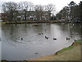
Buckhurst Hill: St John's Pond
This popular pond is located to the south of St John's Church, on the west side of the A121 High Road. The houses beyond the trees are in Osborne Road.
Image: © Nigel Cox
Taken: 4 Jan 2008
0.17 miles