IMAGES TAKEN NEAR TO
Montalt Road, WOODFORD GREEN, IG8 9RU
Introduction
This page details the photographs taken nearby to Montalt Road, IG8 9RU by members of the Geograph project.
The Geograph project started in 2005 with the aim of publishing, organising and preserving representative images for every square kilometre of Great Britain, Ireland and the Isle of Man.

There are currently over 7.5m images from over14,400 individuals and you can help contribute to the project by visiting https://www.geograph.org.uk
Image Map (Loading...)


Getting Data...Please wait
Leaflet Map data © OpenStreetMap
Images are licensed for reuse under creativecommons.org/licenses/by-sa/2.0
Notes
- Clicking on the map will re-center to the selected point.
- The higher the marker number, the further away the image location is from the centre of the postcode.
Image Listing (19 Images Found)
Images are licensed for reuse under creativecommons.org/licenses/by-sa/2.0
Image
Details
Distance
4
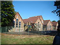
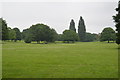
Olympic rings in Woodford Green Primary School
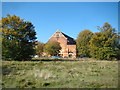
Looking north-northeast from the path into Epping Forest, just inside the left hand edge of the gridsquare.
Image: © Robert Lamb
Taken: 14 Oct 2012
0.16 miles
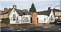
5
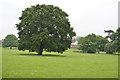
View of Woodford Green URC Church from the path by Potato Pond
Looking west.
Image: © Robert Lamb
Taken: 14 Oct 2012
0.17 miles
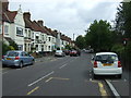
8
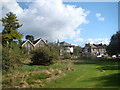
View of houses on Sunset Avenue
Looking south-southeast.
Image: © Robert Lamb
Taken: 14 Oct 2012
0.21 miles
9
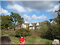
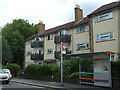
View of houses with attractive balconies on Sunset Avenue
Looking north-northeast.
Image: © Robert Lamb
Taken: 14 Oct 2012
0.21 miles