IMAGES TAKEN NEAR TO
The Charter Road, WOODFORD GREEN, IG8 9RD
Introduction
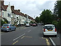
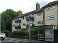
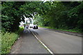
This page details the photographs taken nearby to The Charter Road, IG8 9RD by members of the Geograph project.
The Geograph project started in 2005 with the aim of publishing, organising and preserving representative images for every square kilometre of Great Britain, Ireland and the Isle of Man.

There are currently over 7.5m images from over14,400 individuals and you can help contribute to the project by visiting https://www.geograph.org.uk
Image Map
Images are licensed for reuse under creativecommons.org/licenses/by-sa/2.0
Notes
- Clicking on the map will re-center to the selected point.
- The higher the marker number, the further away the image location is from the centre of the postcode.
Image Listing (32 Images Found)
Images are licensed for reuse under creativecommons.org/licenses/by-sa/2.0
Image
Details
Distance
5
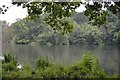
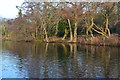
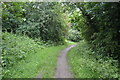
Centenary Walk alongside Highams Park lake
During the reign of King Henry VIIIth, the manor of Higham belonged to Sir Giles Heron. The present manor house was built in 1768 for the then Lord of the Manor, Antony Bacon MP. It was he who first enclosed this part of Epping Forest. In 1794 on the advice of Humphrey Repton he formed the tree-line lake.The lake was created partly to provide water for deer living in the nearby woods. For each project Humphrey Repton produced a "red book" containing overlays showing how the redesigned landscape would look. The red book for Highams Park survives and is kept at the Vestry House Museum in Walthamstow. The lake was formed by widening the River Ching. The manor house is now the central part of Woodford County High School.
In 1891 Sir Courtenay Warner sold the lake, together with a strip of land either side, to the Corporation of the City of London for £6,000, assisted by donations from Walthamstow and Woodford local boards and private individuals. The latter amounted to £1,500. This land was added to Epping Forest and opened to the general public. The Great Eastern Railway took advantage of this new attraction and renamed Hale End station as Higham Park station in 1894 but got rather carried away in advertising the delights of Highams Park as "the most beautiful lake within a day's travel of London". Much of the remaining estate was sold during the 1930s and built on.
The Centenary walk was established in 1978 to celebrate the 100th anniversary of the passing of the Epping Forest Act.
Image: © Marathon
Taken: 1 Apr 2015
0.18 miles