IMAGES TAKEN NEAR TO
Frinton Drive, WOODFORD GREEN, IG8 9ND
Introduction
This page details the photographs taken nearby to Frinton Drive, IG8 9ND by members of the Geograph project.
The Geograph project started in 2005 with the aim of publishing, organising and preserving representative images for every square kilometre of Great Britain, Ireland and the Isle of Man.

There are currently over 7.5m images from over14,400 individuals and you can help contribute to the project by visiting https://www.geograph.org.uk
Image Map
Images are licensed for reuse under creativecommons.org/licenses/by-sa/2.0
Notes
- Clicking on the map will re-center to the selected point.
- The higher the marker number, the further away the image location is from the centre of the postcode.
Image Listing (17 Images Found)
Images are licensed for reuse under creativecommons.org/licenses/by-sa/2.0
Image
Details
Distance
1
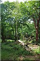
Hornbeam Pollards & Hollow Oak, Walthamstow Forest
It has been many decades since these venerable hornbeams have been harvested for the hardest U.K native timber.
Image: © Glyn Baker
Taken: 23 Jun 2017
0.09 miles
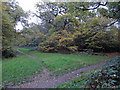
2
Pollarded trees in Walthamstow Forest
A handful of pollarded trees near this footpath junction.
Image: © Roger Jones
Taken: 22 Nov 2011
0.09 miles
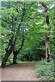
5

Path in Walthamstow Forest
Walthamstow Forest http://www.wildessex.net/sites/Walthamstow%20Forest.htm is part of Epping Forest
Image: © Glyn Baker
Taken: 23 Jun 2017
0.11 miles
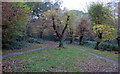
8
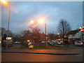
Hale End Road at the junction of Oak Hill
Image: © David Howard
Taken: 8 Dec 2016
0.14 miles