IMAGES TAKEN NEAR TO
Hampstead Avenue, WOODFORD GREEN, IG8 8RG
Introduction
This page details the photographs taken nearby to Hampstead Avenue, IG8 8RG by members of the Geograph project.
The Geograph project started in 2005 with the aim of publishing, organising and preserving representative images for every square kilometre of Great Britain, Ireland and the Isle of Man.

There are currently over 7.5m images from over14,400 individuals and you can help contribute to the project by visiting https://www.geograph.org.uk
Image Map (Loading...)


Getting Data...Please wait
Leaflet Map data © OpenStreetMap
Images are licensed for reuse under creativecommons.org/licenses/by-sa/2.0
Notes
- Clicking on the map will re-center to the selected point.
- The higher the marker number, the further away the image location is from the centre of the postcode.
Image Listing (35 Images Found)
Images are licensed for reuse under creativecommons.org/licenses/by-sa/2.0
Image
Details
Distance
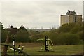
1
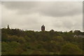
View of the former Claybury Hospital tower from Claybury Park
Now part of the Repton Gate housing development, named after Sir Humphrey Repton. Looking north-northeast.
Image: © Robert Lamb
Taken: 25 Apr 2015
0.06 miles
2
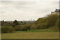
View of the Shard, Walkie Talkie, Gherkin, Heron Tower and Tower 42 from Claybury Park
Looking south-southwest.
Image: © Robert Lamb
Taken: 25 Apr 2015
0.14 miles
3
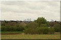
View of Canary Wharf and the Stratford Eye from Claybury Park
Looking south-southwest.
Image: © Robert Lamb
Taken: 25 Apr 2015
0.16 miles
4
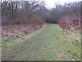
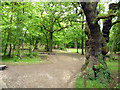
Path into Hospital Hill Woods, Claybury Park
Claybury Park was once part of the Claybury estate, held by Barking Abbey from the 12th century. It contains Claybury and Hospital Hill Woods, remnants of the ancient woodland of Hainault Forest. Claybury was developed into a fine gentleman's estate from 1786 by James Hatch, who built a new mansion, expanded the estate and commissioned Humphry Repton to advise on landscaping the parkland. In 1887 the estate was sold and Claybury Asylum was built by 1893 on the brow of a hill, the first mental hospital built by the new London County Council. From 1893 to 1918 it was called Claybury Asylum, from 1918 to 1937 Claybury Mental Hospital, and from 1937 to its closure in 1995 Claybury Hospital
In 1997 the Health Authority sold the Hospital estate for an exclusive private housing development, renamed Repton Park, but 18 hectares of ancient woodland and 38 hectares of parkland became part of a new public park, Claybury Park. This also incorporated Redbridge Open Space to the south, itself part of the Claybury estate until the 1880s. For more about Claybury Hospital see http://hidden-london.com/gazetteer/claybury/ and http://ezitis.myzen.co.uk/claybury.html and https://en.wikipedia.org/wiki/Claybury_Hospital
This path leads into Hospital Hill Wood. This was a freezing day where early fog had cleared to mist. The nearby ponds were still frozen.
Image: © Marathon
Taken: 25 Jan 2017
0.17 miles
5
View of the Stratford Eye and Arcelo-Mittal Orbit from Claybury Park
Looking south-southwest.
Image: © Robert Lamb
Taken: 25 Apr 2015
0.17 miles
6
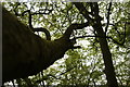
View up the trunk of the Wild Service Tree in Claybury Wood
Looking east.
Image: © Robert Lamb
Taken: 25 Apr 2015
0.18 miles
7
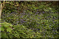
View of bluebells in Claybury Wood #4
Looking north-northeast.
Image: © Robert Lamb
Taken: 25 Apr 2015
0.18 miles
8
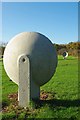
Acoustic Telephone
Part of the play equipment in Claybury Park includes this acoustic telephone. The concrete parabolic reflectors are uncannily similar (except in size) to the acoustic aircraft detectors of the 1930's see Image & Image (Ironically these in the picture were made in Germany). When I was a kid we had to use coco tins and bits of string.
Image: © Glyn Baker
Taken: 27 Nov 2011
0.19 miles
9
Hospital Hill Wood
Part of, or at least contiguous with, Claybury Park.
Image: © Robin Webster
Taken: 2 Jun 2012
0.19 miles
10
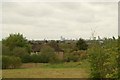
View over East London from Claybury Park
Looking south-southwest, with Owen Waters House on Fullwell Avenue on the right.
Image: © Robert Lamb
Taken: 25 Apr 2015
0.19 miles