IMAGES TAKEN NEAR TO
Lambs Meadow, WOODFORD GREEN, IG8 8QD
Introduction
This page details the photographs taken nearby to Lambs Meadow, IG8 8QD by members of the Geograph project.
The Geograph project started in 2005 with the aim of publishing, organising and preserving representative images for every square kilometre of Great Britain, Ireland and the Isle of Man.

There are currently over 7.5m images from over14,400 individuals and you can help contribute to the project by visiting https://www.geograph.org.uk
Image Map (Loading...)


Getting Data...Please wait
Leaflet Map data © OpenStreetMap
Images are licensed for reuse under creativecommons.org/licenses/by-sa/2.0
Notes
- Clicking on the map will re-center to the selected point.
- The higher the marker number, the further away the image location is from the centre of the postcode.
Image Listing (13 Images Found)
Images are licensed for reuse under creativecommons.org/licenses/by-sa/2.0
Image
Details
Distance
1

Shell petrol station on Southend Road, Woodford
Image: © David Howard
Taken: 4 Apr 2017
0.03 miles
2
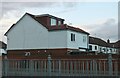
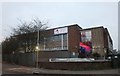
Highly extended house on Southend Road, Clayhall
I wish the council would let me add another section on the back of my house this size.
Image: © David Howard
Taken: 16 Apr 2024
0.03 miles


7
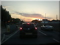
View of a dramatic sky over Woodford Avenue
Looking north-northwest.
Image: © Robert Lamb
Taken: 30 Jun 2015
0.09 miles
9
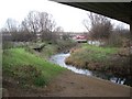
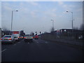
Charlie Brown's
This South Woodford junction has always been known as Charlie Brown's, presumably after the landlord of a pub which stood here rather than the cartoon character. Today it's a concrete jungle of flyovers, but with the modest River Roding flowing beneath. In this view looking north, we are standing under the M11, the bus is travelling west from Ilford towards Walthamstow and the two levels of flyovers in the background carry the spur roads which link the North Circular Road with the motorway.
Image: © John Davies
Taken: 21 Dec 2005
0.22 miles
10
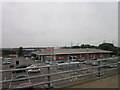
Groupcall on Chigwell Road, Woodford
"Groupcall provides trusted communication, data and identity management solutions for the education, public and business sectors." www.groupcall.com
Image: © David Howard
Taken: 5 Jan 2019
0.23 miles