
IMAGES TAKEN NEAR TO
Gaynes Hill Road, WOODFORD GREEN, IG8 8HU
Introduction
This page details the photographs taken nearby to Gaynes Hill Road, IG8 8HU by members of the Geograph project.
The Geograph project started in 2005 with the aim of publishing, organising and preserving representative images for every square kilometre of Great Britain, Ireland and the Isle of Man.

There are currently over 7.5m images from over14,400 individuals and you can help contribute to the project by visiting https://www.geograph.org.uk
Image Map
Images are licensed for reuse under creativecommons.org/licenses/by-sa/2.0
Notes
- Clicking on the map will re-center to the selected point.
- The higher the marker number, the further away the image location is from the centre of the postcode.
Image Listing (21 Images Found)
Images are licensed for reuse under creativecommons.org/licenses/by-sa/2.0
Image
Details
Distance
2
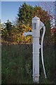
Pump by the Roding
This 19th century water pump was saved from destruction in 1962 and rededicated and restored to its former position in 1997 see Image
Image: © Glyn Baker
Taken: 27 Nov 2011
0.04 miles
3
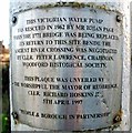
Pump Plaque
Image: © Glyn Baker
Taken: 27 Nov 2011
0.05 miles
4

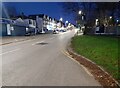
Chigwell Road and Pump
The car is passing over the bridge over the River Roding. The river was diverted during construction of the M11 and now passes on the far side of the motorway behind the photographer. You can take a closer look at the pump Image
Image: © Glyn Baker
Taken: 27 Nov 2011
0.05 miles


8

Green on the A113
The Green on Chigwell Road
Image: © Glyn Baker
Taken: 27 Nov 2011
0.08 miles
9
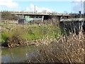
Looking across the River Roding to Roding Valley Park and the M11
Roding Valley Park extends from Redbridge Roundabout in the south to the Redbridge Borough boundary with Essex in the north. This is looking across from where Chigwell Road crosses the river with the M11 immediately beyond up the embankment. The path follows the far bank as can be seen at http://www.geograph.org.uk/photo/5275502
The River Roding rises near Dunmow, then flows through Essex to form Barking Creek as it reaches the River Thames. For more information see https://en.wikipedia.org/wiki/River_Roding and http://www.londonslostrivers.com/river-roding.html and http://www.telegraph.co.uk/travel/cruises/riversandcanals/9885094/Germaine-Greer-its-time-to-take-care-of-Essexs-rivers.html and http://thelostbyway.com/tag/river-roding
Image: © Marathon
Taken: 7 Feb 2017
0.10 miles
10
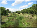
River Roding at Woodford Bridge
A view over the River Roding at Woodford Bridge. The river itself is obscured by the vegetation.
Image: © Malc McDonald
Taken: 17 Aug 2019
0.12 miles