IMAGES TAKEN NEAR TO
Finchingfield Avenue, WOODFORD GREEN, IG8 7JZ
Introduction
This page details the photographs taken nearby to Finchingfield Avenue, IG8 7JZ by members of the Geograph project.
The Geograph project started in 2005 with the aim of publishing, organising and preserving representative images for every square kilometre of Great Britain, Ireland and the Isle of Man.

There are currently over 7.5m images from over14,400 individuals and you can help contribute to the project by visiting https://www.geograph.org.uk
Image Map (Loading...)


Getting Data...Please wait
Leaflet Map data © OpenStreetMap
Images are licensed for reuse under creativecommons.org/licenses/by-sa/2.0
Notes
- Clicking on the map will re-center to the selected point.
- The higher the marker number, the further away the image location is from the centre of the postcode.
Image Listing (28 Images Found)
Images are licensed for reuse under creativecommons.org/licenses/by-sa/2.0
Image
Details
Distance
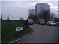
1
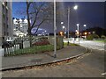
Broadmead Road, Woodford
At the corner of Navestock Crescent
Image: © David Howard
Taken: 21 Nov 2021
0.19 miles
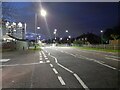
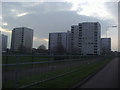
6
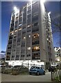
Tower block on the Broadmead Estate, Woodford
Image: © David Howard
Taken: 21 Nov 2021
0.22 miles
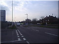
7
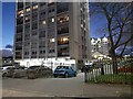
Tower block on the Broadmead Estate, Woodford
Image: © David Howard
Taken: 21 Nov 2021
0.22 miles
10
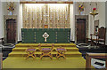
St Barnabas, Woodford Green - Sanctuary
Image: © John Salmon
Taken: 16 Nov 2012
0.23 miles