IMAGES TAKEN NEAR TO
Romford Road, CHIGWELL, IG7 4QW
Introduction
This page details the photographs taken nearby to Romford Road, IG7 4QW by members of the Geograph project.
The Geograph project started in 2005 with the aim of publishing, organising and preserving representative images for every square kilometre of Great Britain, Ireland and the Isle of Man.

There are currently over 7.5m images from over14,400 individuals and you can help contribute to the project by visiting https://www.geograph.org.uk
Image Map
Images are licensed for reuse under creativecommons.org/licenses/by-sa/2.0
Notes
- Clicking on the map will re-center to the selected point.
- The higher the marker number, the further away the image location is from the centre of the postcode.
Image Listing (14 Images Found)
Images are licensed for reuse under creativecommons.org/licenses/by-sa/2.0
Image
Details
Distance
1
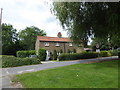
Cottages next to Romford Road
These cottages are near the entrance to Hainault Forest Golf Club.
Image: © Marathon
Taken: 16 Aug 2017
0.04 miles
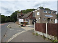
2
Hainault Golf Club, Romford Road
Next door to Image, which is to its left.
Image: © John Baker
Taken: 17 Oct 2013
0.04 miles
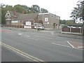
3
Hainault Forest Golf Club
Hainault Forest Golf Club has two 18-hole courses (The Upper and The Lower Course). This is the part of the club house on Romford Road.
Image: © Marathon
Taken: 16 Aug 2017
0.05 miles
4
Hainault Forest Golf Club, Romford Road
Next door to Image which is to its right.
Image: © John Baker
Taken: 17 Oct 2013
0.05 miles
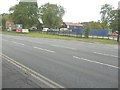
5
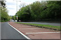
Cycling Centre
Redbridge Cycling Centre http://www.redbridgecyclingcentre.co.uk/ offers a safe environment for on or off road cycling without the worry of motorcars.
Image: © Glyn Baker
Taken: 24 Oct 2010
0.08 miles
6
Five Oaks Lane, Hainault
Once a narrow track this is now a reasonably wide road to a new housing development, but still leads nowhere.
Image: © David Howard
Taken: 4 Nov 2017
0.13 miles
8
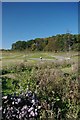
Farmland with a view
This is the view from Romford Road with the towers of the City of London looming large and The Shard dominating. The fields are part of Furze House Farm to the south just over the border with Barking and Dagenham.
Furze House Farm is the last remnant in this area to the west of Romford Road and north of Billet Road of the agricultural landscape which predominated until the 1920s. Although the fields here serve as a reminder of how most of the area once looked, this particular farmland is of relatively recent origin. In the early 19th century this land lay within Hainault Forest. The name 'Furze House' refers to the heathy nature of the Forest, furze being an old name for gorse. It was only after the removal of the Forest's legal protection in 1851 that this area was turned over to agricultural use. The area of open countryside in the far north of Barking & Dagenham and stretching into Redbridge was reduced to the current extent around 1960 when the Marks Gate housing estate to the south was completed.
This is a classic example of how the Green Belt works. To the south of Billet Road is the estate of Marks Gate while to the north is built-up Hainault. See also http://www.geograph.org.uk/photo/5436203
Image: © Marathon
Taken: 16 Aug 2017
0.16 miles
10
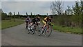
Cyclists racing at Redbridge Cycling Centre ('Hog Hill')
Four cyclists in a 'criterium' road cycling race, photographed by a race marshal.
Photo captured Saturday 1 May 2021 at 13:46.
Image: © Calum Rogers
Taken: 1 May 2021
0.19 miles