IMAGES TAKEN NEAR TO
The Lowe, CHIGWELL, IG7 4LJ
Introduction
This page details the photographs taken nearby to The Lowe, IG7 4LJ by members of the Geograph project.
The Geograph project started in 2005 with the aim of publishing, organising and preserving representative images for every square kilometre of Great Britain, Ireland and the Isle of Man.

There are currently over 7.5m images from over14,400 individuals and you can help contribute to the project by visiting https://www.geograph.org.uk
Image Map
Images are licensed for reuse under creativecommons.org/licenses/by-sa/2.0
Notes
- Clicking on the map will re-center to the selected point.
- The higher the marker number, the further away the image location is from the centre of the postcode.
Image Listing (22 Images Found)
Images are licensed for reuse under creativecommons.org/licenses/by-sa/2.0
Image
Details
Distance
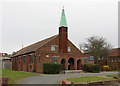
1
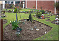
St Paul, Arrowsmith Road - Memorial garden
Image: © John Salmon
Taken: 15 Mar 2011
0.05 miles
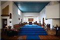
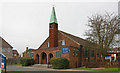
5
St Paul, Arrowsmith Road - South chapel
Image: © John Salmon
Taken: 15 Mar 2011
0.07 miles
7
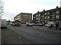
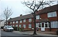
Hainault Housing
Shops and flats in Manford Way, part of the huge Hainault overspill development of the 1950s
Image: © John Davies
Taken: 25 Jan 2006
0.12 miles
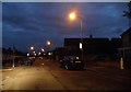
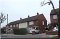
8
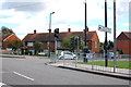
Junction on New North Road
Junction with Elmbridge Road, seen on the right ahead here.
Image: © Trevor Harris
Taken: 18 Sep 2013
0.12 miles