IMAGES TAKEN NEAR TO
Manford Way, CHIGWELL, IG7 4AJ
Introduction
This page details the photographs taken nearby to Manford Way, IG7 4AJ by members of the Geograph project.
The Geograph project started in 2005 with the aim of publishing, organising and preserving representative images for every square kilometre of Great Britain, Ireland and the Isle of Man.

There are currently over 7.5m images from over14,400 individuals and you can help contribute to the project by visiting https://www.geograph.org.uk
Image Map
Images are licensed for reuse under creativecommons.org/licenses/by-sa/2.0
Notes
- Clicking on the map will re-center to the selected point.
- The higher the marker number, the further away the image location is from the centre of the postcode.
Image Listing (6 Images Found)
Images are licensed for reuse under creativecommons.org/licenses/by-sa/2.0
Image
Details
Distance
1

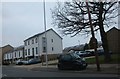
The Forester Public House Hainault
In Burrow Road, it used to be a Watneys house
Image: © Phil Gaskin
Taken: 25 Oct 2011
0.13 miles

5
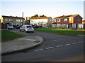
Hainault: Huntsman Road
These are post-war semi-detached houses typical of this area of Hainault, surrounding a small green on the north side of Huntsman Road. The centre block of these three probably represents the original style, while the others reflect changes made through the years by the owners.
Image: © Nigel Cox
Taken: 30 Oct 2007
0.21 miles
6
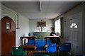
St Paul, Arrowsmith Road - South chapel
Image: © John Salmon
Taken: 15 Mar 2011
0.25 miles