IMAGES TAKEN NEAR TO
Clinton Crescent, ILFORD, IG6 3AW
Introduction
This page details the photographs taken nearby to Clinton Crescent, IG6 3AW by members of the Geograph project.
The Geograph project started in 2005 with the aim of publishing, organising and preserving representative images for every square kilometre of Great Britain, Ireland and the Isle of Man.

There are currently over 7.5m images from over14,400 individuals and you can help contribute to the project by visiting https://www.geograph.org.uk
Image Map
Images are licensed for reuse under creativecommons.org/licenses/by-sa/2.0
Notes
- Clicking on the map will re-center to the selected point.
- The higher the marker number, the further away the image location is from the centre of the postcode.
Image Listing (34 Images Found)
Images are licensed for reuse under creativecommons.org/licenses/by-sa/2.0
Image
Details
Distance

5
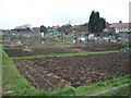
Hainault Allotments
Well-tended and productive allotments in New North Road, Hainault
Image: © John Davies
Taken: 25 Jan 2006
0.12 miles
6
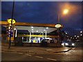
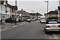
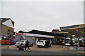
Jet petrol station on New North Road, Hainault
Image: © David Howard
Taken: 4 Nov 2017
0.12 miles
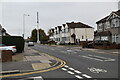
9
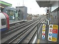
Looking north from Hainault station
Towards the depot for underground stock, with a Central Line train waiting to depart for Grange Hill.
Image: © John Baker
Taken: 4 Dec 2013
0.14 miles
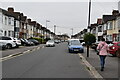
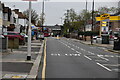
10

Shops along New North Road, Hainault
In the distance the bridge carries Central Line underground trains over the road. The next road on the right, with a lamppost marking its entrance, is Kirby Close.
Image: © John Baker
Taken: 4 Dec 2013
0.14 miles