IMAGES TAKEN NEAR TO
Benrek Close, ILFORD, IG6 2QL
Introduction
This page details the photographs taken nearby to Benrek Close, IG6 2QL by members of the Geograph project.
The Geograph project started in 2005 with the aim of publishing, organising and preserving representative images for every square kilometre of Great Britain, Ireland and the Isle of Man.

There are currently over 7.5m images from over14,400 individuals and you can help contribute to the project by visiting https://www.geograph.org.uk
Image Map (Loading...)


Getting Data...Please wait
Leaflet Map data © OpenStreetMap
Images are licensed for reuse under creativecommons.org/licenses/by-sa/2.0
Notes
- Clicking on the map will re-center to the selected point.
- The higher the marker number, the further away the image location is from the centre of the postcode.
Image Listing (6 Images Found)
Images are licensed for reuse under creativecommons.org/licenses/by-sa/2.0
Image
Details
Distance

3
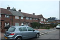
Kingsley Road, Barkingside
The house at the end has been rebuilt since the middle of 2018
Image: © David Howard
Taken: 5 Jan 2019
0.21 miles
4
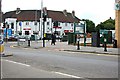
The Old Maypole
Seen from Fencepiece Road, though difficult to get a reasonable shot through all the street furniture.
Image: © Trevor Harris
Taken: 18 Sep 2013
0.22 miles
5
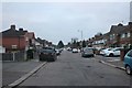
Trelawney Road, Barkingside
Trelawney Road in Barkingside, on the outer fringes of north east London.
Image: © Malc McDonald
Taken: 26 May 2017
0.23 miles
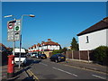
6

St Francis of Assisi, Fencepiece Road, Ilford - Chapel
Image: © John Salmon
Taken: 8 Nov 2004
0.25 miles