IMAGES TAKEN NEAR TO
Charlotte Close, ILFORD, IG6 2HQ
Introduction
This page details the photographs taken nearby to Charlotte Close, IG6 2HQ by members of the Geograph project.
The Geograph project started in 2005 with the aim of publishing, organising and preserving representative images for every square kilometre of Great Britain, Ireland and the Isle of Man.

There are currently over 7.5m images from over14,400 individuals and you can help contribute to the project by visiting https://www.geograph.org.uk
Image Map (Loading...)


Getting Data...Please wait
Leaflet Map data © OpenStreetMap
Images are licensed for reuse under creativecommons.org/licenses/by-sa/2.0
Notes
- Clicking on the map will re-center to the selected point.
- The higher the marker number, the further away the image location is from the centre of the postcode.
Image Listing (3 Images Found)
Images are licensed for reuse under creativecommons.org/licenses/by-sa/2.0
Image
Details
Distance
1
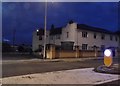
Triple Detached?
Tomswood Hill (L) and Fencepiece Road (R) meet at quite a sharp angle with a sort of triangular plot on the inside of the junction. Three houses jointly occupy the space in a sort of angled terrace arrangement.
Image: © Des Blenkinsopp
Taken: 29 Apr 2024
0.24 miles