IMAGES TAKEN NEAR TO
High Street, ILFORD, IG6 2EA
Introduction
This page details the photographs taken nearby to High Street, IG6 2EA by members of the Geograph project.
The Geograph project started in 2005 with the aim of publishing, organising and preserving representative images for every square kilometre of Great Britain, Ireland and the Isle of Man.

There are currently over 7.5m images from over14,400 individuals and you can help contribute to the project by visiting https://www.geograph.org.uk
Image Map (Loading...)


Getting Data...Please wait
Leaflet Map data © OpenStreetMap
Images are licensed for reuse under creativecommons.org/licenses/by-sa/2.0
Notes
- Clicking on the map will re-center to the selected point.
- The higher the marker number, the further away the image location is from the centre of the postcode.
Image Listing (31 Images Found)
Images are licensed for reuse under creativecommons.org/licenses/by-sa/2.0
Image
Details
Distance
1
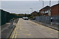
Redevelopment around Fullwell Library, High Street
Planning permission has been granted by Redbridge Council under application number 0496/13/01 for “the space around the library will consist of new access provision and improved and expanded public realm, with the existing building untouched. The space between library and leisure centre will consist of improved landscaping, improved and enlarged access provision to leisure centre, retention of mature trees and new loggia structure adjacent to existing spa wall incorporating small A3 kiosk and creating a new active frontage addressing the High Street. The space between the leisure centre and Virginia Gardens will consist of a new pocket park on the site of the existing terrace, incorporating soft and hard landscaping, new planting and a new A1 unit within a revised yard enclosure to the leisure centre”.
Image: © John Baker
Taken: 4 Dec 2013
0.01 miles
2
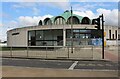
Fulwell Cross Library
This is a grade II listed building https://historicengland.org.uk/listing/the-list/list-entry/1391938
Image: © David Howard
Taken: 9 May 2021
0.02 miles
4
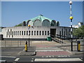
Fullwell Cross: The Fullwell Cross Library
The distinctive circular Fullwell Cross Library with its green copper finish roof was designed by the architect Frederick Gibberd (1908-1984) and was opened in 1968. It comprises a single storey lower structure with narrow vertical windows topped with a higher lantern-like shell with 16 windows providing light to the centre of the main building. It is a Grade II Listed Building.
Gibberd was principally known for his design of Harlow New Town, but was also the architect of Liverpool Metropolitan Cathedral and the London Central Mosque.
This is actually a view of the rear of the library across Craven Gardens.
Image: © Nigel Cox
Taken: 25 Apr 2011
0.04 miles
5
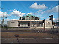
Fullwell Cross Library, Barkingside
Fullwell Cross Library was built in the mid-1960s. The circular building is Grade II Listed as it is deemed to have special architectural interest.
More information about the building is on the Historic England website: https://historicengland.org.uk/listing/the-list/list-entry/1391938
Image: © Malc McDonald
Taken: 23 May 2017
0.04 miles
6
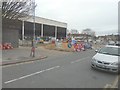
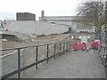
Construction of a new pocket park, Virginia Gardens
Planning permission has been granted by Redbridge Council under application number 0496/13/01 - “the space around the library will consist of new access provision and improved and expanded public realm, with the existing building untouched. The space between (Fullwell) library and leisure centre will consist of improved landscaping, improved and enlarged access provision to leisure centre, retention of mature trees and new loggia structure adjacent to existing spa wall incorporating small A3 kiosk and creating a new active frontage addressing the High Street. The space between the leisure centre and Virginia Gardens (as seen here) will consist of a new pocket park on the site of the existing terrace, incorporating soft and hard landscaping, new planting and a new A1 unit within a revised yard enclosure to the leisure centre”.
Image: © John Baker
Taken: 4 Dec 2013
0.05 miles
7
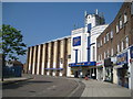
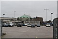
Fullwell Cross: The former State cinema
The State in Fairlop Road was completed in 1938 to the designs of the renowned cinema architect George Coles, but it suffered bomb damage in 1940 and was not reopened until it had been refurbished by ABC Cinemas in 1948. In 1972 it was altered into a twin cinema and bingo operation, but the cinema section closed in 1984. The photographer understands that bingo, currently run by Gala, has continued in the former cinema stalls, while the rest of the cinema at balcony level, and including, it is thought, the original 1938 cafe and ballroom, remains mothballed.
Perhaps surprisingly it is not a Listed Building.
Image: © Nigel Cox
Taken: 25 Apr 2011
0.07 miles

9
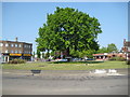
Fullwell Cross: The Fullwell Cross Roundabout
The roundabout with its single prominent tree is on the A123 at its junction with Forest Road, Craven Gardens and Fullwell Avenue. It certainly dates from prior to the Second World War as it is shown on the Ordnance Survey map of 1939.
Image: © Nigel Cox
Taken: 25 Apr 2011
0.09 miles