IMAGES TAKEN NEAR TO
Wincanton Gardens, ILFORD, IG6 2BP
Introduction
This page details the photographs taken nearby to Wincanton Gardens, IG6 2BP by members of the Geograph project.
The Geograph project started in 2005 with the aim of publishing, organising and preserving representative images for every square kilometre of Great Britain, Ireland and the Isle of Man.

There are currently over 7.5m images from over14,400 individuals and you can help contribute to the project by visiting https://www.geograph.org.uk
Image Map (Loading...)


Getting Data...Please wait
Leaflet Map data © OpenStreetMap
Images are licensed for reuse under creativecommons.org/licenses/by-sa/2.0
Notes
- Clicking on the map will re-center to the selected point.
- The higher the marker number, the further away the image location is from the centre of the postcode.
Image Listing (49 Images Found)
Images are licensed for reuse under creativecommons.org/licenses/by-sa/2.0
Image
Details
Distance
3
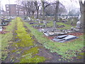
Barkingside Cemetery
Barkingside Cemetery opened in 1923 when the first burial took place. In 1954 when the cemetery had become full an extension was opened on the other side of Longwood Gardens and this became Barkingside Garden of Rest. Barkingside Cemetery is laid out on a simple grid with wide paths and some covered seats. A small hedged plot on the north east side is reserved for former members of Dr Barnardo's Village Home, which had been established in 1875. At that time Barkingside was a small village.
This was a freezing January day where early fog had cleared to mist.
Image: © Marathon
Taken: 25 Jan 2017
0.12 miles

5
Barkingside Cemetery
Barkingside Cemetery opened in 1923 when the first burial took place. In 1954 when the cemetery had become full an extension was opened on the other side of Longwood Gardens and this became Barkingside Garden of Rest. Barkingside Cemetery is laid out on a simple grid with wide paths and some covered seats. A small hedged plot on the north east side is reserved for former members of Dr Barnardo's Village Home, which had been established in 1875. At that time Barkingside was a small village.
This was a freezing January day where early fog had cleared to mist.
Image: © Marathon
Taken: 25 Jan 2017
0.13 miles
6
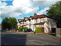
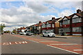
Houses on Looe Gardens, Barkingside
Houses on Looe Gardens in Barkingside, in north east London's outer suburbs.
This image was taken right on the boundary of two Geograph squares. The photographer was just within square Image, most of the housing terrace is within the same square, but the end of the terrace to the right of the image is in the neighbouring square, Image
Image: © Malc McDonald
Taken: 23 May 2017
0.15 miles
7
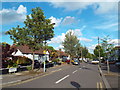
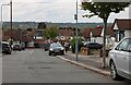
Greenleafe Drive, Barkingside
Greenleafe Drive in Barkingside, in outer north east London.
Image: © Malc McDonald
Taken: 23 May 2017
0.15 miles
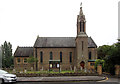
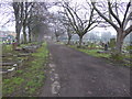
10

Barkingside Garden of Rest
Barkingside Garden of Rest, photographed in early evening sunshine in May.
Image: © Malc McDonald
Taken: 23 May 2017
0.16 miles