IMAGES TAKEN NEAR TO
High Street, ILFORD, IG6 2AY
Introduction
This page details the photographs taken nearby to High Street, IG6 2AY by members of the Geograph project.
The Geograph project started in 2005 with the aim of publishing, organising and preserving representative images for every square kilometre of Great Britain, Ireland and the Isle of Man.

There are currently over 7.5m images from over14,400 individuals and you can help contribute to the project by visiting https://www.geograph.org.uk
Image Map (Loading...)


Getting Data...Please wait
Leaflet Map data © OpenStreetMap
Images are licensed for reuse under creativecommons.org/licenses/by-sa/2.0
Notes
- Clicking on the map will re-center to the selected point.
- The higher the marker number, the further away the image location is from the centre of the postcode.
Image Listing (72 Images Found)
Images are licensed for reuse under creativecommons.org/licenses/by-sa/2.0
Image
Details
Distance
1

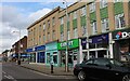
View of street art above Fashion Nails (originally the Mayfair Stationers) on Barkingside High Street
Looking south-southeast.
Image: © Robert Lamb
Taken: 12 Sep 2017
0.02 miles
2
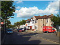
Streetlight replacement scheme on Barkingside High Street
During the summer of 2008, Barkingside High Street received a street light replacement scheme to coincide with the installing of CCTV cameras. However, I can't see why this was necessary as CCTV cameras need "white" light to be able to give good colour rendition, but the light output on the older lamps was "white" anyway! The older lanterns were only installed in 2004, so they are still new! What a waste! View taken from the junction with Waverley Gardens looking south-southwest towards the Fremantle Road and Baron Gardens traffic lights.
Image: © Robert Lamb
Taken: 7 Aug 2008
0.02 miles
3
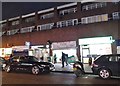
Douglas Allen estate agents, Barkingside
Image: © David Howard
Taken: 9 May 2021
0.05 miles
5
Access road to Barkingside Sainsbury's store
The Sainsbury's store on Tanners Lane at its junction with the A123 Cranbrook Road and Barkingside High Street has its own private access road for staff to park their cars and deliveries (namely Sainsbury's lorries) to gain easy access to the rear of the store. I do think, however, that parking cars here is a very poor idea as there have been several collisions of Sainsbury's lorries with the lamp posts which light the road. I took this more for the lamp posts, but thought that this image was worthy to use as a Geograph. View taken from Baron Gardens looking south-southeast towards Tanners Lane (the Sainsbury's store is the greyish building behind the trees in the background).
Image: © Robert Lamb
Taken: 7 Jun 2009
0.07 miles

8
Fairlop Road, Barkingside
Fairlop Road in Barkingside, in north east London's outer suburbs. The no entry signs are a clue that this is a one-way street.
Image: © Malc McDonald
Taken: 23 May 2017
0.12 miles
10
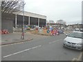
Construction of a new pocket park, Virginia Gardens
Planning permission has been granted by Redbridge Council under application number 0496/13/01 - “the space around the library will consist of new access provision and improved and expanded public realm, with the existing building untouched. The space between (Fullwell) library and leisure centre will consist of improved landscaping, improved and enlarged access provision to leisure centre, retention of mature trees and new loggia structure adjacent to existing spa wall incorporating small A3 kiosk and creating a new active frontage addressing the High Street. The space between the leisure centre and Virginia Gardens (as seen here) will consist of a new pocket park on the site of the existing terrace, incorporating soft and hard landscaping, new planting and a new A1 unit within a revised yard enclosure to the leisure centre”.
Image: © John Baker
Taken: 4 Dec 2013
0.14 miles