IMAGES TAKEN NEAR TO
Crown Road, ILFORD, IG6 1NE
Introduction
This page details the photographs taken nearby to Crown Road, IG6 1NE by members of the Geograph project.
The Geograph project started in 2005 with the aim of publishing, organising and preserving representative images for every square kilometre of Great Britain, Ireland and the Isle of Man.

There are currently over 7.5m images from over14,400 individuals and you can help contribute to the project by visiting https://www.geograph.org.uk
Image Map
Images are licensed for reuse under creativecommons.org/licenses/by-sa/2.0
Notes
- Clicking on the map will re-center to the selected point.
- The higher the marker number, the further away the image location is from the centre of the postcode.
Image Listing (79 Images Found)
Images are licensed for reuse under creativecommons.org/licenses/by-sa/2.0
Image
Details
Distance

5
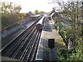
Barkingside Station
This is a view of Barkingside station taken from the bridge on Station Rd looking south.
Image: © Glyn Baker
Taken: 2 Dec 2005
0.04 miles
8
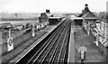
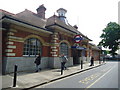
Barkingside Station
View southward, towards Newbury Park and London: LT Central Line (Hainault Loop), since 31/5/48; until 29/11/47 this was the LNER (ex-GER) Fairlop Loop, Ilford - Woodford. Hence it is a typical Great Eastern station, little changed apart from the UndergrounD signs.
Image: © Ben Brooksbank
Taken: 1 Apr 1961
0.07 miles