IMAGES TAKEN NEAR TO
Hatley Avenue, ILFORD, IG6 1EG
Introduction
This page details the photographs taken nearby to Hatley Avenue, IG6 1EG by members of the Geograph project.
The Geograph project started in 2005 with the aim of publishing, organising and preserving representative images for every square kilometre of Great Britain, Ireland and the Isle of Man.

There are currently over 7.5m images from over14,400 individuals and you can help contribute to the project by visiting https://www.geograph.org.uk
Image Map (Loading...)


Getting Data...Please wait
Leaflet Map data © OpenStreetMap
Images are licensed for reuse under creativecommons.org/licenses/by-sa/2.0
Notes
- Clicking on the map will re-center to the selected point.
- The higher the marker number, the further away the image location is from the centre of the postcode.
Image Listing (8 Images Found)
Images are licensed for reuse under creativecommons.org/licenses/by-sa/2.0
Image
Details
Distance
1
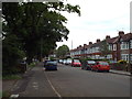
Ashurst Drive, near Barkingside
Ashurst Drive is a residential road in the outer suburbs of north east London.
Image: © Malc McDonald
Taken: 5 Jun 2017
0.08 miles
2
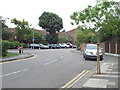
Ashurst Drive, near Barkingside
A bend in the road on Ashurst Drive, in north east London's outer suburbs. At this point, Ashurst Drive continues straight ahead into a cul-de-sac. The road around the bend is Barnardo Drive.
Barnardo Drive doubtlessly takes its name from the Dr. Barnardo's charity, which has its headquarters close by. More information about Dr. Barnardo's is available here: http://www.barnardos.org.uk/
Image: © Malc McDonald
Taken: 5 Jun 2017
0.14 miles
3
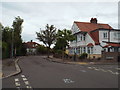
Ashurst Drive, near Barkingside
Ashurst Drive is a residential road near Barkingside, in north east London's outer suburbs.
The marks on the road surface indicate that road markings are about to be provided for "Quietway" route Q6, one of a network of cycle routes which make use of quieter back streets rather than main roads. Route Q6 will run from Aldgate, in Central London, to Hainault on the Greater London/Essex border. More information about the Quietways is on Transport for London's website: https://tfl.gov.uk/travel-information/improvements-and-projects/quietways
Image: © Malc McDonald
Taken: 5 Jun 2017
0.20 miles
4
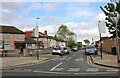
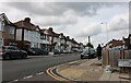
Princes Road at the junction of Horns Road
Image: © David Howard
Taken: 9 May 2021
0.22 miles
5
Horns Road, Newbury Park
At the corner of Chase Lane
Image: © David Howard
Taken: 9 May 2021
0.22 miles
6
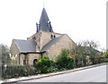
St Laurence, Donington Avenue, Barkingside
Image: © John Salmon
Taken: 8 Nov 2004
0.25 miles
7
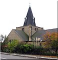
St Laurence, Donington Avenue, Barkingside
Image: © John Salmon
Taken: 8 Nov 2004
0.25 miles
8
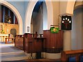
St Laurence, Donington Avenue, Barkingside - Ambo
Image: © John Salmon
Taken: 8 Nov 2004
0.25 miles