IMAGES TAKEN NEAR TO
Ravensbourne Gardens, ILFORD, IG5 0XG
Introduction
This page details the photographs taken nearby to Ravensbourne Gardens, IG5 0XG by members of the Geograph project.
The Geograph project started in 2005 with the aim of publishing, organising and preserving representative images for every square kilometre of Great Britain, Ireland and the Isle of Man.

There are currently over 7.5m images from over14,400 individuals and you can help contribute to the project by visiting https://www.geograph.org.uk
Image Map
Images are licensed for reuse under creativecommons.org/licenses/by-sa/2.0
Notes
- Clicking on the map will re-center to the selected point.
- The higher the marker number, the further away the image location is from the centre of the postcode.
Image Listing (43 Images Found)
Images are licensed for reuse under creativecommons.org/licenses/by-sa/2.0
Image
Details
Distance
1
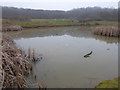
Pond in Claybury Park
Claybury Park was once part of the Claybury estate, held by Barking Abbey from the 12th century. It contains Claybury and Hospital Hill Woods, remnants of the ancient woodland of Hainault Forest. Claybury was developed into a fine gentleman's estate from 1786 by James Hatch, who built a new mansion, expanded the estate and commissioned Humphry Repton to advise on landscaping the parkland. In 1887 the estate was sold and Claybury Asylum was built by 1893 on the brow of a hill, the first mental hospital built by the new London County Council. From 1893 to 1918 it was called Claybury Asylum, from 1918 to 1937 Claybury Mental Hospital, and from 1937 to its closure in 1995 Claybury Hospital
In 1997 the Health Authority sold the Hospital estate for an exclusive private housing development, renamed Repton Park, but 18 hectares of ancient woodland and 38 hectares of parkland became part of a new public park, Claybury Park. This also incorporated Redbridge Open Space to the south, itself part of the Claybury estate until the 1880s. For more about Claybury Hospital see http://hidden-london.com/gazetteer/claybury/ and http://ezitis.myzen.co.uk/claybury.html and https://en.wikipedia.org/wiki/Claybury_Hospital
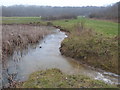
This pond is in the south of the park next to Ravensbourne Gardens. This was a freezing day where early fog had cleared to mist. The eastern edge of the pond together with the outlet stream were still frozen.
Image: © Marathon
Taken: 25 Jan 2017
0.04 miles
2
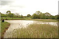
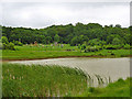
View across the lake in Claybury Park
Looking south-southeast.
Image: © Robert Lamb
Taken: 25 Apr 2015
0.04 miles
3
View of houses on Ravensbourne Gardens from Claybury Park
Looking south-southwest.
Image: © Robert Lamb
Taken: 25 Apr 2015
0.04 miles
4
View of a no fishing sign hiding among the reeds in the lake in Claybury Park
Looking south-southwest.
Image: © Robert Lamb
Taken: 25 Apr 2015
0.05 miles
5
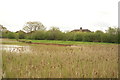
View of the reeds in the lake in Claybury Park
Looking south-southwest.
Image: © Robert Lamb
Taken: 25 Apr 2015
0.06 miles
6
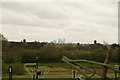
View of Canary Wharf from Claybury Park
Looking south-southwest.
Image: © Robert Lamb
Taken: 25 Apr 2015
0.07 miles
7
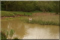
Pond, Claybury Park
A country park partly in the extensive grounds of a former mental hospital.
Image: © Robin Webster
Taken: 2 Jun 2012
0.07 miles
8
Pond in Claybury Park
Claybury Park was once part of the Claybury estate, held by Barking Abbey from the 12th century. It contains Claybury and Hospital Hill Woods, remnants of the ancient woodland of Hainault Forest. Claybury was developed into a fine gentleman's estate from 1786 by James Hatch, who built a new mansion, expanded the estate and commissioned Humphry Repton to advise on landscaping the parkland. In 1887 the estate was sold and Claybury Asylum was built by 1893 on the brow of a hill, the first mental hospital built by the new London County Council. From 1893 to 1918 it was called Claybury Asylum, from 1918 to 1937 Claybury Mental Hospital, and from 1937 to its closure in 1995 Claybury Hospital
In 1997 the Health Authority sold the Hospital estate for an exclusive private housing development, renamed Repton Park, but 18 hectares of ancient woodland and 38 hectares of parkland became part of a new public park, Claybury Park. This also incorporated Redbridge Open Space to the south, itself part of the Claybury estate until the 1880s.
For more about Claybury Hospital see http://hidden-london.com/gazetteer/claybury/ and http://ezitis.myzen.co.uk/claybury.html and https://en.wikipedia.org/wiki/Claybury_Hospital
This pond is in the south of the park next to Ravensbourne Gardens. This was a freezing day where early fog had cleared to mist. The pond was still frozen.
Image: © Marathon
Taken: 25 Jan 2017
0.07 miles
9
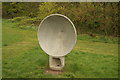
View of one of the concrete reflectors of the acoustic telephone in the children's play area in Claybury Park #2
This is the second receiver of the acoustic telephone. Looking east.
Image: © Robert Lamb
Taken: 25 Apr 2015
0.08 miles
10
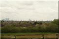
View of Canary Wharf and the Stratford Eye from Claybury Park #2
Looking south-southwest.
Image: © Robert Lamb
Taken: 25 Apr 2015
0.08 miles