IMAGES TAKEN NEAR TO
Humphrey Close, ILFORD, IG5 0RW
Introduction
This page details the photographs taken nearby to Humphrey Close, IG5 0RW by members of the Geograph project.
The Geograph project started in 2005 with the aim of publishing, organising and preserving representative images for every square kilometre of Great Britain, Ireland and the Isle of Man.

There are currently over 7.5m images from over14,400 individuals and you can help contribute to the project by visiting https://www.geograph.org.uk
Image Map
Images are licensed for reuse under creativecommons.org/licenses/by-sa/2.0
Notes
- Clicking on the map will re-center to the selected point.
- The higher the marker number, the further away the image location is from the centre of the postcode.
Image Listing (40 Images Found)
Images are licensed for reuse under creativecommons.org/licenses/by-sa/2.0
Image
Details
Distance
1
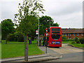
Route 169 at the terminus
A dedicated turning circle is provided at Clayhall, The Glade bus stop. Stagecoach fleet number 19784 is on duty, nearly ready to return to Barking.
Image: © Robin Webster
Taken: 2 Jun 2012
0.04 miles
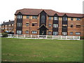
2
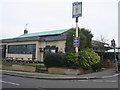
The Unicorn pub
The Unicorn Pub is a popular public house, it hosts many theme nights such as Elvis night, they provide enjoyable entertainment. It is on the corner of Caterham and Clayhall Avenue surrounded with sweet shops, a launderette and a video shop. It is also close to a public secondary school Caterham High, and opposite the pub are many bungalows and semi-detached houses.
Image: © Caterham High Students
Taken: 14 Mar 2008
0.09 miles
3
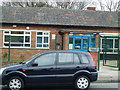
Health Centre
A health centre on Heathcote Avenue. It is a beautiful health centre that serves the public well.
Image: © Caterham High Students
Taken: 27 Mar 2008
0.09 miles
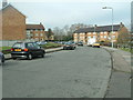
4
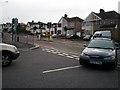
Caterham Avenue
Quite a busy road near to Caterham High School a lot of traffic and polluted.
Image: © Caterham High Students
Taken: 28 Mar 2008
0.12 miles
5
Local area house
A nice house in the middle of the field between Caterham High School and the local bus stop.
Taken by George, Luke and Jack.
Image: © Caterham High Students
Taken: 13 Mar 2008
0.12 miles
7
Littered greenery
This is a picture of a park and it's got a lot of trees which give us fresh air, and lots of people are affecting this lovely park by dropping litter under the trees.
Image: © Caterham High Students
Taken: 27 Mar 2008
0.13 miles
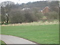
8
Clayhall, The Glade
Clayhall is one of the many pleasant places in our local area. The picture above is of Clayhall park.
Image: © Caterham High Students
Taken: 28 Mar 2008
0.14 miles
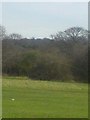
9
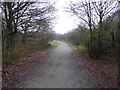
Ash Plantation, Claybury Park
Claybury Park was once part of the Claybury estate, held by Barking Abbey from the 12th century. It contains Claybury and Hospital Hill Woods, remnants of the ancient woodland of Hainault Forest. Claybury was developed into a fine gentleman's estate from 1786 by James Hatch, who built a new mansion, expanded the estate and commissioned Humphry Repton to advise on landscaping the parkland. In 1887 the estate was sold and Claybury Asylum was built by 1893 on the brow of a hill, the first mental hospital built by the new London County Council. From 1893 to 1918 it was called Claybury Asylum, from 1918 to 1937 Claybury Mental Hospital, and from 1937 to its closure in 1995 Claybury Hospital
In 1997 the Health Authority sold the Hospital estate for an exclusive private housing development, renamed Repton Park, but 18 hectares of ancient woodland and 38 hectares of parkland became part of a new public park, Claybury Park. This also incorporated Redbridge Open Space to the south, itself part of the Claybury estate until the 1880s. For more about Claybury Hospital see http://hidden-london.com/gazetteer/claybury/ and http://ezitis.myzen.co.uk/claybury.html and https://en.wikipedia.org/wiki/Claybury_Hospital
This path runs through Ash Plantation which is part of what was Redbridge Open Space to the south. This was part of the Claybury estate until the 1880s and has now been incorporated once again into Claybury Park.
Image: © Marathon
Taken: 25 Jan 2017
0.14 miles
10
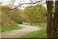
View of a double bend in the path from the lake to Roding Lane North in Claybury Park
Looking south-southwest.
Image: © Robert Lamb
Taken: 25 Apr 2015
0.14 miles