IMAGES TAKEN NEAR TO
Clayhall Avenue, ILFORD, IG5 0LF
Introduction
This page details the photographs taken nearby to Clayhall Avenue, IG5 0LF by members of the Geograph project.
The Geograph project started in 2005 with the aim of publishing, organising and preserving representative images for every square kilometre of Great Britain, Ireland and the Isle of Man.

There are currently over 7.5m images from over14,400 individuals and you can help contribute to the project by visiting https://www.geograph.org.uk
Image Map
Images are licensed for reuse under creativecommons.org/licenses/by-sa/2.0
Notes
- Clicking on the map will re-center to the selected point.
- The higher the marker number, the further away the image location is from the centre of the postcode.
Image Listing (5 Images Found)
Images are licensed for reuse under creativecommons.org/licenses/by-sa/2.0
Image
Details
Distance
1
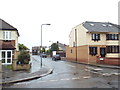
Peel Drive, Clayhall
Peel Drive in north east London's outer suburbs.
This image was taken in heavy rain, on a dull evening in May.
Image: © Malc McDonald
Taken: 18 May 2017
0.12 miles
5
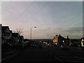
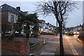
View of the west from Clayhall Avenue
Looking south-southwest.
Image: © Robert Lamb
Taken: 30 Nov 2012
0.25 miles