IMAGES TAKEN NEAR TO
Heatherley Drive, ILFORD, IG5 0JF
Introduction
This page details the photographs taken nearby to Heatherley Drive, IG5 0JF by members of the Geograph project.
The Geograph project started in 2005 with the aim of publishing, organising and preserving representative images for every square kilometre of Great Britain, Ireland and the Isle of Man.

There are currently over 7.5m images from over14,400 individuals and you can help contribute to the project by visiting https://www.geograph.org.uk
Image Map
Images are licensed for reuse under creativecommons.org/licenses/by-sa/2.0
Notes
- Clicking on the map will re-center to the selected point.
- The higher the marker number, the further away the image location is from the centre of the postcode.
Image Listing (9 Images Found)
Images are licensed for reuse under creativecommons.org/licenses/by-sa/2.0
Image
Details
Distance
1
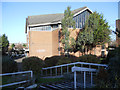
St. John Vianney Catholic Church
St. John Vianney Catholic Church is situated in Stoneleigh Road Ilford. One of its unique features is that it has installed a Cinema Organ. The organ was from the Ritz (ABC) Nuneaton and was purchased and installed by Father Gerard Kerr (the then priest of St. John Vianney) between 1967/8.
Image: © Richard Dunn
Taken: 30 Nov 2011
0.11 miles
2
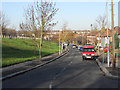
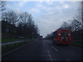
Claybury Broadway Ilford
Claybury Broadway Ilford Essex. Taken from Stoneleigh Road on a crisp winter morning. The road to the left is the A1400 Woodford Avenue between "Charlie Brown's Roundabout" and Gants Hill.
Image: © Richard Dunn
Taken: 30 Nov 2011
0.16 miles
3
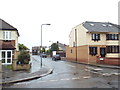
Peel Drive, Clayhall
Peel Drive in north east London's outer suburbs.
This image was taken in heavy rain, on a dull evening in May.
Image: © Malc McDonald
Taken: 18 May 2017
0.20 miles
6
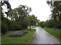
Clayhall Park, Clayhall
Clayhall Park in north east London's outer suburbs. This imagew as taken on a dull and very wet May evening. Because of the rain, there were very few people in the park.
Image: © Malc McDonald
Taken: 18 May 2017
0.23 miles
7
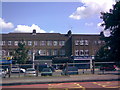
Looking down at Claybury Broadway from the A1400 Woodford Avenue
This small parade of shops is known as Claybury Broadway and is located off Clayhall Avenue, running alongside the A1400 Woodford Avenue and leading into Stoneleigh Road. Shops in shot include the Clayhall Fish Bar, Norman Goldberg Kosher Butchers and Joe's Food Ltd, as well as an off-licence called Star Wine at the extreme left of the picture.
Image: © Robert Lamb
Taken: 17 Aug 2008
0.24 miles
8
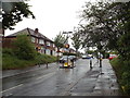
Lord Avenue, Clayhall
Lord Avenue is a residential road in north east London's outer suburbs. The width restriction prevents large vehicles such as lorries or buses using this road as a short cut.
Image: © Malc McDonald
Taken: 18 May 2017
0.25 miles
9
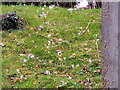
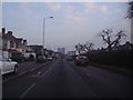
View of crocuses on a bank next to Woodford Avenue
Looking southwest.
Image: © Robert Lamb
Taken: 21 Feb 2021
0.25 miles