IMAGES TAKEN NEAR TO
Park View Gardens, Woodford Avenue, ILFORD, IG4 5NP
Introduction
This page details the photographs taken nearby to Park View Gardens, Woodford Avenue, IG4 5NP by members of the Geograph project.
The Geograph project started in 2005 with the aim of publishing, organising and preserving representative images for every square kilometre of Great Britain, Ireland and the Isle of Man.

There are currently over 7.5m images from over14,400 individuals and you can help contribute to the project by visiting https://www.geograph.org.uk
Image Map (Loading...)


Getting Data...Please wait
Leaflet Map data © OpenStreetMap
Images are licensed for reuse under creativecommons.org/licenses/by-sa/2.0
Notes
- Clicking on the map will re-center to the selected point.
- The higher the marker number, the further away the image location is from the centre of the postcode.
Image Listing (23 Images Found)
Images are licensed for reuse under creativecommons.org/licenses/by-sa/2.0
Image
Details
Distance
1
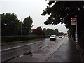
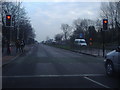
A1400 Woodford Avenue near Redbridge
The A1400 Woodford Avenue, photographed on a dull and very wet May evening during the rush hour.
The road is a dual carriageway, traffic heading in the opposite direction is hidden by a hedge along the central reservation.
Image: © Malc McDonald
Taken: 18 May 2017
0.02 miles
2
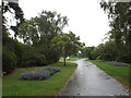
View of London from Clayhall Park #2
Looking south-southwest.
Image: © Robert Lamb
Taken: 21 Feb 2021
0.02 miles
3
View of London from Clayhall Park #3
Looking south-southwest.
Image: © Robert Lamb
Taken: 21 Feb 2021
0.03 miles
4
View of London from Clayhall Park
Looking south-southwest.
Image: © Robert Lamb
Taken: 21 Feb 2021
0.03 miles
5
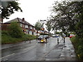
Woodford Avenue, Clayhall
These pedestrian lights were not on Streetview, and the bus stop has been moved from next to the subway on the left to in front of it to make way for the crossing.
Image: © David Howard
Taken: 31 Jan 2012
0.05 miles
6
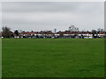
Lord Avenue, Clayhall
Lord Avenue is a residential road in north east London's outer suburbs. The width restriction prevents large vehicles such as lorries or buses using this road as a short cut.
Image: © Malc McDonald
Taken: 18 May 2017
0.07 miles
7
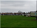
Clayhall Park, Clayhall
Clayhall Park in north east London's outer suburbs. This imagew as taken on a dull and very wet May evening. Because of the rain, there were very few people in the park.
Image: © Malc McDonald
Taken: 18 May 2017
0.07 miles
8
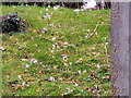
View of crocuses on a bank next to Woodford Avenue
Looking southwest.
Image: © Robert Lamb
Taken: 21 Feb 2021
0.10 miles
9
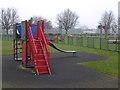
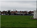
Playground in Clayhall Park
Clayhall Park is on former land of the Manor of Clay Hall, which was broken up in 1927. First mentioned in 1203 when it was owned by Barking Abbey, it probably remained in ownership of the de la Claie or Clay family until 1313 and then passed through various owners. The manor house and grounds were first called Clayhall in 1410.The manor house was once a substantial building as it was the residence of rich and titled owners. It was demolished in the mid-18th century and replaced by a farmhouse and buildings. Clayhall Park opened to the public in 1934 and the farmhouse, outbuildings and chapel were demolished in 1935.
Image: © Marathon
Taken: 25 Jan 2017
0.12 miles
10
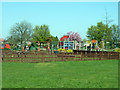
Play area, Clayhall Park
In front is a fenced area with picnic tables.
Image: © Robin Webster
Taken: 9 Apr 2011
0.13 miles