IMAGES TAKEN NEAR TO
Beehive Lane, ILFORD, IG4 5EF
Introduction
This page details the photographs taken nearby to Beehive Lane, IG4 5EF by members of the Geograph project.
The Geograph project started in 2005 with the aim of publishing, organising and preserving representative images for every square kilometre of Great Britain, Ireland and the Isle of Man.

There are currently over 7.5m images from over14,400 individuals and you can help contribute to the project by visiting https://www.geograph.org.uk
Image Map
Images are licensed for reuse under creativecommons.org/licenses/by-sa/2.0
Notes
- Clicking on the map will re-center to the selected point.
- The higher the marker number, the further away the image location is from the centre of the postcode.
Image Listing (54 Images Found)
Images are licensed for reuse under creativecommons.org/licenses/by-sa/2.0
Image
Details
Distance
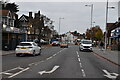
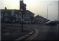
3
Eastern Avenue at the junction with Beehive Lane
Image: © David Howard
Taken: 31 Jan 2012
0.09 miles
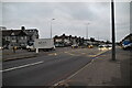
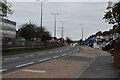
4

Mazda Car Lot Eastern Avenue
Car lot is at junction with Beehive Lane
Image: © PAUL FARMER
Taken: 7 Feb 2009
0.10 miles
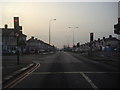
5
Eastern Avenue at the junction with Beehive Lane
Image: © David Howard
Taken: 31 Jan 2012
0.10 miles
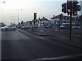
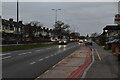
6
Eastern Avenue at the junction with Beehive Lane
Image: © David Howard
Taken: 31 Jan 2012
0.10 miles
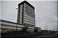
9
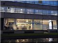
Wentworth House, Gants Hill
It is around 13 storeys depending how you count the floors.
Image: © David Howard
Taken: 5 Mar 2017
0.12 miles