IMAGES TAKEN NEAR TO
Castle Drive, ILFORD, IG4 5AE
Introduction
This page details the photographs taken nearby to Castle Drive, IG4 5AE by members of the Geograph project.
The Geograph project started in 2005 with the aim of publishing, organising and preserving representative images for every square kilometre of Great Britain, Ireland and the Isle of Man.

There are currently over 7.5m images from over14,400 individuals and you can help contribute to the project by visiting https://www.geograph.org.uk
Image Map
Images are licensed for reuse under creativecommons.org/licenses/by-sa/2.0
Notes
- Clicking on the map will re-center to the selected point.
- The higher the marker number, the further away the image location is from the centre of the postcode.
Image Listing (59 Images Found)
Images are licensed for reuse under creativecommons.org/licenses/by-sa/2.0
Image
Details
Distance
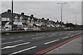
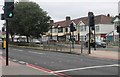
2
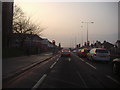
Junction of Eastern Avenue and The Drive
Image: © David Howard
Taken: 31 Jan 2012
0.10 miles
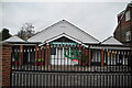
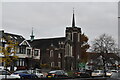
3

The Drive Pre-school
Apparently converted from the hall associated with the Methodist church beyond, it is run by them but is stated to be open to all faiths or none.
Image: © Robin Webster
Taken: 9 Apr 2011
0.10 miles
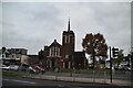
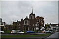

10
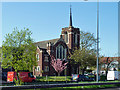
The Drive Methodist Church
Viewed across the A12, Eastern Avenue. The church is on the corner of the A12 and The Drive, the latter being the access to the church and several associated buildings behind it.
Image: © Robin Webster
Taken: 9 Apr 2011
0.12 miles