IMAGES TAKEN NEAR TO
Castleton Road, ILFORD, IG3 9QP
Introduction
This page details the photographs taken nearby to Castleton Road, IG3 9QP by members of the Geograph project.
The Geograph project started in 2005 with the aim of publishing, organising and preserving representative images for every square kilometre of Great Britain, Ireland and the Isle of Man.

There are currently over 7.5m images from over14,400 individuals and you can help contribute to the project by visiting https://www.geograph.org.uk
Image Map
Images are licensed for reuse under creativecommons.org/licenses/by-sa/2.0
Notes
- Clicking on the map will re-center to the selected point.
- The higher the marker number, the further away the image location is from the centre of the postcode.
Image Listing (25 Images Found)
Images are licensed for reuse under creativecommons.org/licenses/by-sa/2.0
Image
Details
Distance
1
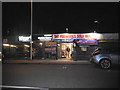
Webb's Garden Centre, Goodmayes
It has been refurbished over the last year
Image: © David Howard
Taken: 21 Oct 2017
0.07 miles
2
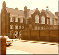
Goodmayes Primary School
Airthrie Road, Goodmayes
Image: © Kenneth Kind
Taken: Unknown
0.07 miles
3
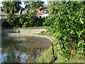
The dirty corner of the lake
All of the debris in the Goodmayes Park lake has ended up here.
Image: © Robin Webster
Taken: 25 Jun 2011
0.16 miles
5
The dirty corner of the lake
All of the debris in the Goodmayes Park lake has ended up here.
Image: © Robin Webster
Taken: 25 Jun 2011
0.17 miles
6
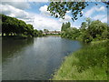
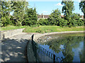
The lake in Goodmayes Park
Goodmayes Park was laid out in 1901 to provide a green 'lung' for the new Mayfield Estate, built by developer A Cameron Corbett, who donated land for the park to the Urban District Council. The area grew up following the arrival of the railway in 1901 and is named after Goodmayes Farm, which once stood on what is now the park. The park was opened to the public in 1905.
Goodmayes Park is divided by Mayesbrook Road into two compartments, that in the north having a lake formed by damming the Mayes Brook. The lake is divided by a footbridge. This is the view from the footbridge looking to the northern part of the lake.
A fuller description of the park can be seen at http://www.londongardensonline.org.uk/gardens-online-record.asp?ID=RED015
Image: © Marathon
Taken: 15 Jun 2016
0.18 miles
8
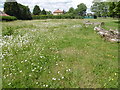
Wildflower area in Goodmayes Park
Goodmayes Park was laid out in 1901 to provide a green 'lung' for the new Mayfield Estate, built by developer A Cameron Corbett, who donated land for the park to the Urban District Council. The area grew up following the arrival of the railway in 1901 and is named after Goodmayes Farm, which once stood on what is now the park. The park was opened to the public in 1905.
Goodmayes Park is divided by Mayesbrook Road into two compartments, that in the north having a lake formed by damming the Mayes Brook. The lake is divided by a footbridge. This wildflower area is just west of the southern part of the lake.
A fuller description of the park can be seen at http://www.londongardensonline.org.uk/gardens-online-record.asp?ID=RED015
Image: © Marathon
Taken: 15 Jun 2016
0.21 miles
9
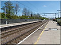
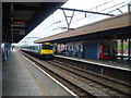
Goodmayes station
The line through here was opened on 20th June 1839 by the Eastern Counties Railway, as the Mile End (temporary terminus) to Romford section of what was to become the Great Eastern Main Line. The London terminus was moved in July 1840 to Shoreditch (later renamed Bishopsgate), and at the eastern end the line was extended out to Brentwood in the same year. Colchester was reached by 1843. Liverpool Street opened in stages from February 1874. The line was quadrupled to Ilford in 1895 and in 1899 out to Seven Kings. In 1902 the quadruple track was extended from Seven Kings through Chadwell Heath to Romford, Goodmayes station was opened on 18th February 1901.
In this photograph these are the original lines, now the slow lines, while the fast lines dating from 1902 are out of sight to the right beyond the railings. The next station in this direction is Chadwell Heath.
Image: © Marathon
Taken: 4 May 2016
0.21 miles
10
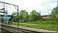
Goodmayes footbridge
The footbridge connects two schools on either side of the railway line between Goodmayes and Chadwell Heath Stations.
Image: © Clint Mann
Taken: 3 May 2016
0.21 miles