IMAGES TAKEN NEAR TO
Kinfauns Road, ILFORD, IG3 9QL
Introduction
This page details the photographs taken nearby to Kinfauns Road, IG3 9QL by members of the Geograph project.
The Geograph project started in 2005 with the aim of publishing, organising and preserving representative images for every square kilometre of Great Britain, Ireland and the Isle of Man.

There are currently over 7.5m images from over14,400 individuals and you can help contribute to the project by visiting https://www.geograph.org.uk
Image Map (Loading...)


Getting Data...Please wait
Leaflet Map data © OpenStreetMap
Images are licensed for reuse under creativecommons.org/licenses/by-sa/2.0
Notes
- Clicking on the map will re-center to the selected point.
- The higher the marker number, the further away the image location is from the centre of the postcode.
Image Listing (53 Images Found)
Images are licensed for reuse under creativecommons.org/licenses/by-sa/2.0
Image
Details
Distance
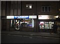
3
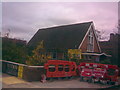
Goodmayes Baptist Church
This church is located on the corner of Kinfauns Road and Goodmayes Lane. View taken looking east.
Image: © Robert Lamb
Taken: 15 Nov 2008
0.10 miles

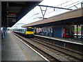
5
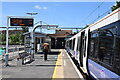
Goodmayes Station - Elizabeth Line
A westbound train about to leave Platform 3. The Elizabeth Line has just opened to the public this week.
Image: © Trevor Harris
Taken: 27 May 2022
0.10 miles
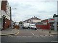
6
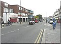
Looking south-southeast along Goodmayes Road
The building, on the left, clad in scaffolding, is numbers 51-53. A description of the work being carried out can be found on Redbridge Council’s website under planning application 2382/10 which states “erection of part two storey, part three storey building with three (A1/A2) units at ground floor. 9 x one bedroom flats at upper floor level. New vehicular access of(f) Kinfauns Road”. Kinfauns Road is the next left beyond the bus.
Image: © John Baker
Taken: 17 Oct 2013
0.10 miles
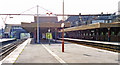
7
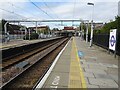
Goodmayes railway station, Greater London
Opened in 1901 by the Great Eastern Railway on its line from London Liverpool Street to Shenfield.
View south west towards Seven Kings and London. In the eight years since Image was taken from the adjacent platform, new platform railings and Transport for London signage have appeared.
Image: © Nigel Thompson
Taken: 15 Oct 2020
0.10 miles
8
Goodmayes station, 1995
View westward, towards Stratford and London Liverpool Street: ex-GER London - Colchester - Ipswich - Norwich main line, electrified as far as Shenfield in 1949. The Local (Slow) lines are on the left.
Image: © Ben Brooksbank
Taken: 13 Apr 1995
0.10 miles