IMAGES TAKEN NEAR TO
Mayesbrook Road, ILFORD, IG3 9PJ
Introduction
This page details the photographs taken nearby to Mayesbrook Road, IG3 9PJ by members of the Geograph project.
The Geograph project started in 2005 with the aim of publishing, organising and preserving representative images for every square kilometre of Great Britain, Ireland and the Isle of Man.

There are currently over 7.5m images from over14,400 individuals and you can help contribute to the project by visiting https://www.geograph.org.uk
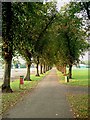
Image Map
Images are licensed for reuse under creativecommons.org/licenses/by-sa/2.0
Notes
- Clicking on the map will re-center to the selected point.
- The higher the marker number, the further away the image location is from the centre of the postcode.
Image Listing (33 Images Found)
Images are licensed for reuse under creativecommons.org/licenses/by-sa/2.0
Image
Details
Distance
1
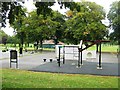
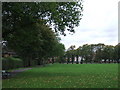
Goodmayes Park
Goodmayes Park is in two distinct halves to the north of Mayesbrook Road it is ornamental and to the south it is given over to sports fields. This picture was taken from the south west corner of the ornamental park.
Image: © Glyn Baker
Taken: 22 Sep 2005
0.08 miles
3
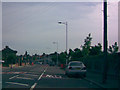
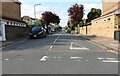
New modern lamp posts on Goodmayes Lane
In mid-2008, these new modern lamp posts were installed on Goodmayes Lane as the old 1980s lamp posts with Philips SGS203 lanterns were getting a little worse for wear. The new lanterns are made in Belgium by a company called Urbis and are called Furyos. I took this shot through the rear screen of the car as it is a nice, sweeping curve and gives the perfect opportunity to really appreciate these installations. View taken near the junction of Goodmayes Lane and Longbridge Road, looking north-northwest.
Image: © Robert Lamb
Taken: 14 Jun 2008
0.16 miles
4
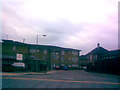
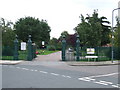
Entrance to Oaklea Lodge and Mayesbrook Primary School
Oaklea Lodge provides residential care for the elderly. This road is also used for vehicular access to Mayesbrook Primary School, the main building of which can be seen in the background. View taken looking west-southwest in the direction of Ilford.
Image: © Robert Lamb
Taken: 15 Nov 2008
0.17 miles
5
Goodmayes Park
Early autumn in Goodmayes Park.
Image: © Malc McDonald
Taken: 2 Oct 2010
0.18 miles
6
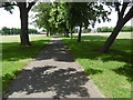
Avenue of trees in Goodmayes Park
Goodmayes Park was laid out in 1901 to provide a green 'lung' for the new Mayfield Estate, built by developer A Cameron Corbett, who donated land for the park to the Urban District Council. The area grew up following the arrival of the railway in 1901 and is named after Goodmayes Farm, which once stood on what is now the park. The park was opened to the public in 1905.
Goodmayes Park is divided by Mayesbrook Road into two compartments, that in the north having a lake formed by damming the Mayes Brook. The lake is divided by a footbridge. This is the view as the park is entered from Holden Close.
A fuller description of the park can be seen at http://www.londongardensonline.org.uk/gardens-online-record.asp?ID=RED015
Image: © Marathon
Taken: 15 Jun 2016
0.18 miles
8
Goodmayes Park entrance
Entrance to Goodmayes Park on Abbotsford Road at the junction with Aberdour Road.
Image: © Malc McDonald
Taken: 2 Oct 2010
0.20 miles
9

All Saints Parish Church, Goodmayes
Founded 1913
Image: © Ken Blackhurst
Taken: 2 Aug 2002
0.20 miles