IMAGES TAKEN NEAR TO
Goodmayes Lane, ILFORD, IG3 9PB
Introduction
This page details the photographs taken nearby to Goodmayes Lane, IG3 9PB by members of the Geograph project.
The Geograph project started in 2005 with the aim of publishing, organising and preserving representative images for every square kilometre of Great Britain, Ireland and the Isle of Man.

There are currently over 7.5m images from over14,400 individuals and you can help contribute to the project by visiting https://www.geograph.org.uk
Image Map (Loading...)


Getting Data...Please wait
Leaflet Map data © OpenStreetMap
Images are licensed for reuse under creativecommons.org/licenses/by-sa/2.0
Notes
- Clicking on the map will re-center to the selected point.
- The higher the marker number, the further away the image location is from the centre of the postcode.
Image Listing (52 Images Found)
Images are licensed for reuse under creativecommons.org/licenses/by-sa/2.0
Image
Details
Distance
3
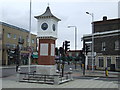
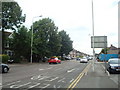
Clock Tower, Goodmayes
Clock tower at the junction of Goodmayes Lane and Green Lane. It is dated 2000 AD.
Image: © Malc McDonald
Taken: 2 Oct 2010
0.08 miles
8
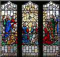
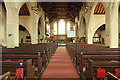
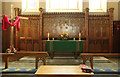
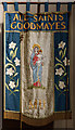
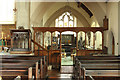
All Saints, Goodmayes - Stained glass window
Image: © John Salmon
Taken: 9 Oct 2013
0.09 miles