IMAGES TAKEN NEAR TO
New Road, ILFORD, IG3 8AP
Introduction
This page details the photographs taken nearby to New Road, IG3 8AP by members of the Geograph project.
The Geograph project started in 2005 with the aim of publishing, organising and preserving representative images for every square kilometre of Great Britain, Ireland and the Isle of Man.

There are currently over 7.5m images from over14,400 individuals and you can help contribute to the project by visiting https://www.geograph.org.uk
Image Map (Loading...)


Getting Data...Please wait
Leaflet Map data © OpenStreetMap
Images are licensed for reuse under creativecommons.org/licenses/by-sa/2.0
Notes
- Clicking on the map will re-center to the selected point.
- The higher the marker number, the further away the image location is from the centre of the postcode.
Image Listing (79 Images Found)
Images are licensed for reuse under creativecommons.org/licenses/by-sa/2.0
Image
Details
Distance
1
View of Pioneer Point from High Road Seven Kings
Looking south-southwest.
Image: © Robert Lamb
Taken: 25 Feb 2014
0.05 miles
2

View of Pioneer Point from High Road Seven Kings #2
Looking south-southwest.
Image: © Robert Lamb
Taken: 25 Feb 2014
0.06 miles
4
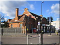
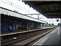
Seven Kings railway station
The station buildings are of a very similar design to those at Goodmayes, the next station down the line eastwards Image The scheduled journey time to Liverpool Street from here is 19 minutes.
Image: © Nigel Cox
Taken: 30 Oct 2007
0.08 miles
5
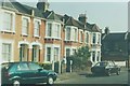
Clandon Road, Seven Kings: 1997
From left to right - the numbering of the houses is from 35 to 41.
Image: © John Baker
Taken: 2 Apr 1997
0.09 miles
6
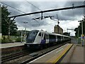
Seven Kings: up local train
Unit 345043 in new Elizabeth Line branding brings up the rear of a train heading for Liverpool Street station, where this part of the line still terminates at present. Eventually, services will run through to Paddington and beyond.
Image: © Stephen Craven
Taken: 30 May 2022
0.09 miles
7
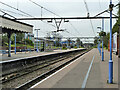
Seven Kings station
The line through here was opened on 20th June 1839 by the Eastern Counties Railway, as the Mile End (temporary terminus) to Romford section of what was to become the Great Eastern Main Line. The London terminus was moved in July 1840 to Shoreditch (later renamed Bishopsgate), and at the eastern end the line was extended out to Brentwood in the same year. Colchester was reached by 1843. Liverpool Street opened in stages from February 1874. The line was quadrupled to Ilford in 1895 and in 1899 out to Seven Kings, at which stage Seven Kings station opened on 1st March 1899. In 1902 the quadruple track was extended from Seven Kings to Romford.
In this photograph the original lines, now the slow lines are to the right while the fast lines dating from 1902 are out of sight to the left beyond railings. A TfL train bound for Liverpool Street is just leaving. The next station in this direction is Ilford.
Image: © Marathon
Taken: 4 May 2016
0.09 miles
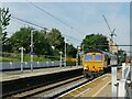
9
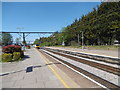
Seven Kings station, 2011
Looking from platform 4 towards Liverpool Street.
Image: © Robin Webster
Taken: 2 Apr 2011
0.10 miles
10
Seven Kings: diesel hauled freightliner
A freightliner trains headed by loco 66735. I'm not sure whether this is heading for the Thames ports (Tilbury / London Gateway) or the East Coast ones (Felixstowe / Harwich). The railway network would allow for either possibility.
Image: © Stephen Craven
Taken: 2 Jun 2022
0.10 miles