IMAGES TAKEN NEAR TO
Aldborough Road North, ILFORD, IG2 7SY
Introduction
This page details the photographs taken nearby to Aldborough Road North, IG2 7SY by members of the Geograph project.
The Geograph project started in 2005 with the aim of publishing, organising and preserving representative images for every square kilometre of Great Britain, Ireland and the Isle of Man.

There are currently over 7.5m images from over14,400 individuals and you can help contribute to the project by visiting https://www.geograph.org.uk
Image Map
Images are licensed for reuse under creativecommons.org/licenses/by-sa/2.0
Notes
- Clicking on the map will re-center to the selected point.
- The higher the marker number, the further away the image location is from the centre of the postcode.
Image Listing (52 Images Found)
Images are licensed for reuse under creativecommons.org/licenses/by-sa/2.0
Image
Details
Distance
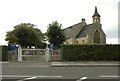
1

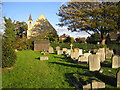
Bridle Path at Aldborough Hatch
This photo was taken looking east along the Bridle Path that runs for ¾ of a mile between Aldborough Hatch and Barkingside. The Church is St Peter’s Aldborough Hatch.
Image: © Glyn Baker
Taken: 2 Dec 2005
0.07 miles
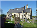
2
Aldborough Hatch: St Peter's Church and churchyard
The Church is reputedly built from the Portland stone blocks from the original Westminster Bridge when it was demolished in the 1860s. The Church's website is here http://www.stpetersah.org.uk/ This view is taken from the churchyard and from the other side of the hedge from Glyn's.
Image: © Nigel Cox
Taken: 30 Oct 2007
0.07 miles
3
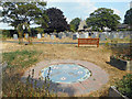
St Peter's Community Memorial Garden
In a corner of the churchyard. Created in 2017 but not looking its best in the scorching dry Summer of 2018.
Image: © Des Blenkinsopp
Taken: 21 Jul 2018
0.09 miles
4
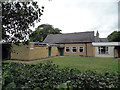
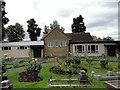
Church Halls And Scout Headquarters Aldborough Hatch
The flat roofed building on the left is the headquarters of the 1st Aldborough Hatch (St. Peter's) Scout Group and was built in the mid 1970s. The pitch roofed building in the middle was the church school built in 1867. It ceased to be a school in 1912 and is now used as a church hall. It is locally listed. The flat roofed building on the right is a church hall built in the middle of the 20th century. The church is in the background.
Image: © Phil Gaskin
Taken: 17 Jul 2012
0.09 miles
5
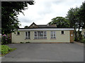
Church Halls Aldborough Hatch
The flat roofed building at the front is a church hall built in the middle of the 20th century.The pitch roofed building behind was the church school built in 1867. It ceased to be a school in 1912 and is now used as a church hall. It is locally listed.
Image: © Phil Gaskin
Taken: 17 Jul 2012
0.10 miles
6
Church Halls Aldborough Hatch
The pitch roofed building in the middle was the church school built in 1867. It ceased to be a school in 1912 and is now used as a church hall. It is locally listed. The flat roofed building on the left is a church hall built in the middle of the 20th century. The flat roofed building on the right is the vestry.
Image: © Phil Gaskin
Taken: 17 Jul 2012
0.10 miles
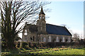
7
St. Peter: the parish church of Aldborough Hatch
This small ragstone church, designed by Ashpitel, was built in 1862.
Image: © Robert Edwards
Taken: 16 Oct 2009
0.10 miles
9
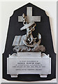
St Peter. Aldborough Hatch - Wall monument
Image: © John Salmon
Taken: 24 Feb 2016
0.11 miles
10
St Peter's, Aldborough Hatch
Of no great age, built 1862.
Image: © Robin Webster
Taken: 9 Apr 2011
0.11 miles