IMAGES TAKEN NEAR TO
Bush Close, ILFORD, IG2 7NL
Introduction
This page details the photographs taken nearby to Bush Close, IG2 7NL by members of the Geograph project.
The Geograph project started in 2005 with the aim of publishing, organising and preserving representative images for every square kilometre of Great Britain, Ireland and the Isle of Man.

There are currently over 7.5m images from over14,400 individuals and you can help contribute to the project by visiting https://www.geograph.org.uk
Image Map
Images are licensed for reuse under creativecommons.org/licenses/by-sa/2.0
Notes
- Clicking on the map will re-center to the selected point.
- The higher the marker number, the further away the image location is from the centre of the postcode.
Image Listing (134 Images Found)
Images are licensed for reuse under creativecommons.org/licenses/by-sa/2.0
Image
Details
Distance
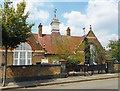
1

View of the Barkingside Progressive Synagogue from Perrymans Farm Road
Looking south-southwest.
Image: © Robert Lamb
Taken: 7 Oct 2013
0.04 miles
5
School to Synagogue to Islamic Centre
It still says Infants School on the gate, but this building in Ferrymans Farm Road was a synagogue when this picture was taken in 2013 Image
The Jewish star is still on the top of the weather vane but the notice by the door says it's an Islamic Centre now.
Image: © Des Blenkinsopp
Taken: 21 Jul 2018
0.05 miles
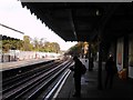
6
On Newbury Park Station
Standing on the Central Line westbound platform looking north towards the bridge which carries Ferrymans Farm Road over the railway.
Image: © Trevor Harris
Taken: 1 Mar 2020
0.05 miles
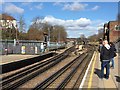
7
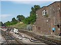
Looking north up the Central line tracks from Newbury Park station
It looks quite peaceful, but I can assure you it isn't! This scene is buzzing with the constant roar of traffic from the A12 Eastern Avenue behind, King George Avenue behind the railings to the left and of course Central line trains! This is the view looking north up the Central line tracks from the westbound platform at Newbury Park. The bridge in the background carries Perryman's Farm Road.
Image: © Robert Lamb
Taken: 3 Nov 2010
0.06 miles
8
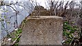
View of the World War II tank traps next to the Central line tracks on Footpath 97
Looking north-northwest, towards Barkingside.
Image: © Robert Lamb
Taken: 6 Mar 2018
0.09 miles
9
Central line train
Coming out of Newbury Park Station
Image: © John Myers
Taken: 14 Sep 2009
0.09 miles
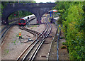
10
Signal box outside Newbury Park Underground station
Construction of the line from Ilford through Barkingside and Chigwell to join the Epping and Ongar line at Woodford started in 1900, although powers had been obtained as early as 1846. The stations were built to high standards. Passenger and local freight operations started on 1st May 1903. At first the service worked from either Fenchurch Street or Liverpool Street and then back both ways round the loop. Everything was done to prepare for heavy passenger traffic, misplaced optimism being shown by the stations which all had substantial buildings and long platforms. Barkingside was the most handsome of the six stations.
Newbury Park station at the time of its opening had new houses being erected nearby at the north-eastern edge of growing Ilford.
Despite all this, patronage was very low until the building boom of the late 1920s and early 1930s when almost all the land between the eastern bank of the River Roding and the Hainault Loop was filled with small houses up to a point well north of Barkingside.
Eventually pressure from commuters in the new houses and the formation of the London Passenger Transport Board led to the proposal to extend the Central London line from its then terminus at Liverpool Street to Stratford and on to Leyton to join the Loughton line. At Leytonstone the new Tube would be made under Eastern Avenue as far as Newbury Park where the Underground would take over services on the Hainault Loop. Work was well underway from October 1936 when they stopped in 1940 because of the War. Plessey used the tunnels during the War for the manufacture of aircraft components, but after the War work began again and the first Tube trains were operated between Leytonstone and Newbury Park from Sunday 14th December 1947. LNER steam ran for the last time on Saturday 29th November 1947. Hainault was reached by Underground trains on 31st May 1948 and Woodford via Chigwell on 21st November.
The connection between Newbury Park and the main line east of Ilford was disconnected on 17th March 1956. Much of the old track was filled to ground level to provide allotments.
This view looks beyond the end of the down platform at Newbury Park and past the signal box. As there is little housing to the east of the line beyond Newbury Park some trains turn round here before heading back to Central London. One such train is seen just beyond the station.
Image: © Marathon
Taken: 24 Aug 2016
0.09 miles