IMAGES TAKEN NEAR TO
Birkbeck Road, ILFORD, IG2 7NF
Introduction
This page details the photographs taken nearby to Birkbeck Road, IG2 7NF by members of the Geograph project.
The Geograph project started in 2005 with the aim of publishing, organising and preserving representative images for every square kilometre of Great Britain, Ireland and the Isle of Man.

There are currently over 7.5m images from over14,400 individuals and you can help contribute to the project by visiting https://www.geograph.org.uk
Image Map
Images are licensed for reuse under creativecommons.org/licenses/by-sa/2.0
Notes
- Clicking on the map will re-center to the selected point.
- The higher the marker number, the further away the image location is from the centre of the postcode.
Image Listing (87 Images Found)
Images are licensed for reuse under creativecommons.org/licenses/by-sa/2.0
Image
Details
Distance
3
Derelict building on Buntingbridge Road, Newbury Park
It appears to have been the Cranvale residential care home. https://www.cqc.org.uk/location/1-135960167/contact
Image: © David Howard
Taken: 9 May 2021
0.07 miles
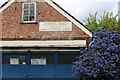
5
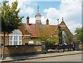
School to Synagogue to Islamic Centre
It still says Infants School on the gate, but this building in Ferrymans Farm Road was a synagogue when this picture was taken in 2013 Image
The Jewish star is still on the top of the weather vane but the notice by the door says it's an Islamic Centre now.
Image: © Des Blenkinsopp
Taken: 21 Jul 2018
0.08 miles
6
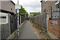
Start of footpath 97 in Perkins Road
Footpath 97 has an entrance to Sainsbury's and the retail park and goes to Oaks Lane.
Image: © Phil Gaskin
Taken: 4 Jun 2017
0.08 miles
7
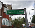
Footpath 97 sign in Perkins Road
Footpath 97 goes to Oaks Lane and has an entrance to Sainsbury's and the retail park.
Image: © Phil Gaskin
Taken: 4 Jun 2017
0.09 miles
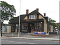
8

View of the Barkingside Progressive Synagogue from Perrymans Farm Road
Looking south-southwest.
Image: © Robert Lamb
Taken: 7 Oct 2013
0.09 miles
10
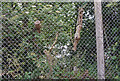
Interesting arboriculture on footpath 97
The tree branches appear to have grown into the fencing before being pruned.
Image: © Phil Gaskin
Taken: 4 Jun 2017
0.11 miles