IMAGES TAKEN NEAR TO
Perrymans Farm Road, ILFORD, IG2 7LD
Introduction
This page details the photographs taken nearby to Perrymans Farm Road, IG2 7LD by members of the Geograph project.
The Geograph project started in 2005 with the aim of publishing, organising and preserving representative images for every square kilometre of Great Britain, Ireland and the Isle of Man.

There are currently over 7.5m images from over14,400 individuals and you can help contribute to the project by visiting https://www.geograph.org.uk
Image Map
Images are licensed for reuse under creativecommons.org/licenses/by-sa/2.0
Notes
- Clicking on the map will re-center to the selected point.
- The higher the marker number, the further away the image location is from the centre of the postcode.
Image Listing (99 Images Found)
Images are licensed for reuse under creativecommons.org/licenses/by-sa/2.0
Image
Details
Distance
1
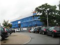
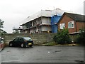
Derelict building on Buntingbridge Road, Newbury Park
It appears to have been the Cranvale residential care home. https://www.cqc.org.uk/location/1-135960167/contact
Image: © David Howard
Taken: 9 May 2021
0.07 miles
4
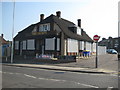
Newbury Park: The former County and former Horns Tavern
A couple of months after Alex took his Image and The County appears to have closed to business. Looking at the closing down party Halloween notices still left outside the pub this probably happened around the end of October 2010.
The pub was on Horns Road. Old Ordnance Survey maps show that this area was originally a linear village known as Ley Street and an older building called the Horns Tavern is shown on the 1896 map. Probably the same building is also shown on the 1864 map but without a name. The building is still shown on the map of 1919, but by 1939 the current building is shown as the Horns Tavern.
Image: © Nigel Cox
Taken: 25 Apr 2011
0.10 miles
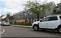
6
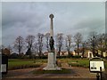
Ilford War Memorial Gardens
This pleasant park is the Ilford War Memorial Gardens, located on the A12 Eastern Avenue just west of Newbury Park tube station. According to the aerial photograph on "Where's the path?" (http://wtp2.appspot.com/wheresthepath.htm?lat=51.575089229596195&lon=0.0899505615234375&gz=17&oz=8>=1), the flowerbed behind the memorial itself is in the shape of a cross. View taken looking north-northwest from the A12.
Image: © Robert Lamb
Taken: 3 Nov 2010
0.12 miles
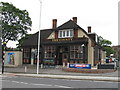
7
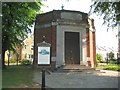
Ilford War Memorial Hall
In the way of a description the photographer can do no better than to quote, with all due acknowledgement, directly from the London Borough of Redbridge sign in the foreground.
"The Ilford War Memorial Hall records the names of 1,159 Ilford men killed in the 1914-1918 War.
The Memorial Hall was opened on 25 June 1927 by Lady Patricia Ramsay (formerly H.R.H. Princess Patricia of Connaught). It was intended to serve both as a memorial and as the entrance hall to the new Children's Ward - known as the Walter Stevens Wing - of what was then the Ilford Emergency Hospital, later to become the King George V Hospital.
The Children's Ward (since demolished), the Memorial Hall, the Memorial Gardens and the Memorial Monument at the entrance to the gardens were paid for by money raised from donations to the Ilford War Memorial Fund.
Despite the original intention, the Memorial Hall was never used as the entrance to the Children's Hospital and, when the hospital closed in 1993, few people knew about the Memorial. However the historic significance of the building was recognised, and a case was successfully made in 1995 for the Memorial Hall and the Memorial Monument to be added to the statutory list of buildings of architectural or historic interest (Grade II). The building was restored as part of a planning agreement between the London Borough of Redbridge and the developers of the adjoining hospital site. The Council is now responsible for its upkeep.
For reasons of security, it is not possible to allow unsupervised access to the Memorial Hall but it open on Remembrance Day and at other times of year. It is also possible to obtain access at other times by appointment."
The building, which is octagonal in plan, was designed by the architects C J Dawson & Allardyce.
Image: © Nigel Cox
Taken: 25 Apr 2011
0.13 miles
9
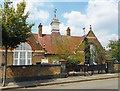
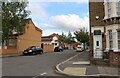
School to Synagogue to Islamic Centre
It still says Infants School on the gate, but this building in Ferrymans Farm Road was a synagogue when this picture was taken in 2013 Image
The Jewish star is still on the top of the weather vane but the notice by the door says it's an Islamic Centre now.
Image: © Des Blenkinsopp
Taken: 21 Jul 2018
0.13 miles