IMAGES TAKEN NEAR TO
Eastern Avenue, ILFORD, IG2 7HH
Introduction
This page details the photographs taken nearby to Eastern Avenue, IG2 7HH by members of the Geograph project.
The Geograph project started in 2005 with the aim of publishing, organising and preserving representative images for every square kilometre of Great Britain, Ireland and the Isle of Man.

There are currently over 7.5m images from over14,400 individuals and you can help contribute to the project by visiting https://www.geograph.org.uk
Image Map
Images are licensed for reuse under creativecommons.org/licenses/by-sa/2.0
Notes
- Clicking on the map will re-center to the selected point.
- The higher the marker number, the further away the image location is from the centre of the postcode.
Image Listing (90 Images Found)
Images are licensed for reuse under creativecommons.org/licenses/by-sa/2.0
Image
Details
Distance
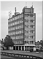
1

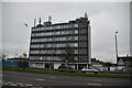
Newbury Park: Newbury House, 890 - 900 Eastern Avenue
This 7 storey 1960s office block is wedge-shaped rather than rectangular. This end face has 12 window bays whereas the far face, out of sight, only has 6. This is the view from Hertford Road which runs parallel to the A12 Eastern Avenue.
Image: © Nigel Cox
Taken: 25 Apr 2011
0.00 miles
3
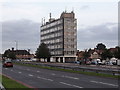
Newbury House across A12 Eastern Avenue
Image: © Chris Brown
Taken: 28 Aug 2018
0.01 miles

5

Newbury House, Eastern Avenue
This rather elegantly-proportioned office block nearly opposite Newbury Park underground station is like an outlier of the cluster at nearby Gants Hill.
Image: © Chris Brown
Taken: 28 Aug 2018
0.01 miles
6
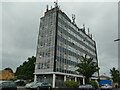
Newbury House, Hertford Road
Another contributor gives more information about the building Image The number of transmitters on top is probably because it is adjacent to the A12 trunk road and
Image: © Stephen Craven
Taken: 30 May 2022
0.01 miles
8
Newbury House, Newbury Park
1960s(?) office block, showing the influence of Swiss-French architect Le Corbusier.
Image: © Jim Osley
Taken: 20 Apr 2017
0.03 miles
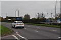
9
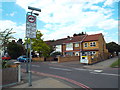
Crownfield Avenue, Newbury Park
Crownfield Avenue is a residential street which leads off the busy A12 road in Newbury Park, in east London.
The sign indicates that a night-time lorry ban is in force. The ban also applies on Saturday afternoons and all day on Sundays.
Image: © Malc McDonald
Taken: 1 Jun 2017
0.03 miles
10
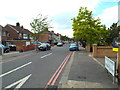
Crownfield Avenue, Newbury Park
Crownfield Avenue is a residential road in Newbury Park, in the suburbs of east London.
The parking restrictions are denoted by red lines ratehr than the more usual yellow ones. "Red route" markings apply to London's strategic trunk roads. Here they give a clue that Crownfield Avenue is just off a busy road, the A12.
Image: © Malc McDonald
Taken: 1 Jun 2017
0.04 miles