IMAGES TAKEN NEAR TO
Kimberley Avenue, ILFORD, IG2 7AT
Introduction
This page details the photographs taken nearby to Kimberley Avenue, IG2 7AT by members of the Geograph project.
The Geograph project started in 2005 with the aim of publishing, organising and preserving representative images for every square kilometre of Great Britain, Ireland and the Isle of Man.

There are currently over 7.5m images from over14,400 individuals and you can help contribute to the project by visiting https://www.geograph.org.uk
Image Map
Images are licensed for reuse under creativecommons.org/licenses/by-sa/2.0
Notes
- Clicking on the map will re-center to the selected point.
- The higher the marker number, the further away the image location is from the centre of the postcode.
Image Listing (26 Images Found)
Images are licensed for reuse under creativecommons.org/licenses/by-sa/2.0
Image
Details
Distance
3
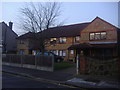
Trillo Court, St Johns Road, Newbury Park
Image: © David Howard
Taken: 31 Jan 2012
0.18 miles
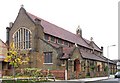
5
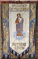
St John, St John's Road, Seven Kings - Banner
MU banner
Image: © John Salmon
Taken: 8 Nov 2004
0.19 miles
6
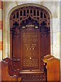
St John, St John's Road, Seven Kings - Memorial WW1
Image: © John Salmon
Taken: 8 Nov 2004
0.19 miles
7

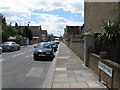
Landsdowne Rd, Seven Kings
This is Landsdowne Rd (not a rugby ball in sight!) one of eight parallel almost cloned streets running north towards Seven King’s Park.
Image: © Glyn Baker
Taken: 14 Apr 2006
0.19 miles
8
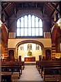
St John, St John's Road, Seven Kings - East end
Image: © John Salmon
Taken: 8 Nov 2004
0.19 miles
9

St John, St John's Road, Seven Kings - Font
Image: © John Salmon
Taken: 8 Nov 2004
0.19 miles
