IMAGES TAKEN NEAR TO
Shere Road, ILFORD, IG2 6TQ
Introduction
This page details the photographs taken nearby to Shere Road, IG2 6TQ by members of the Geograph project.
The Geograph project started in 2005 with the aim of publishing, organising and preserving representative images for every square kilometre of Great Britain, Ireland and the Isle of Man.

There are currently over 7.5m images from over14,400 individuals and you can help contribute to the project by visiting https://www.geograph.org.uk
Image Map
Images are licensed for reuse under creativecommons.org/licenses/by-sa/2.0
Notes
- Clicking on the map will re-center to the selected point.
- The higher the marker number, the further away the image location is from the centre of the postcode.
Image Listing (63 Images Found)
Images are licensed for reuse under creativecommons.org/licenses/by-sa/2.0
Image
Details
Distance

6
Waremead Road
Looking south east, with the college/school fencing on the left.
Image: © Trevor Harris
Taken: 6 Feb 2016
0.10 miles
8
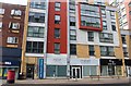
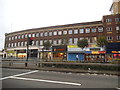
New block on Eastern Avenue, Gants Hill
This was completed a year or two ago, I had been following it since it started going up, and often narrowed the road causing jams half way back to Walthamstow.
Image: © David Howard
Taken: 25 May 2019
0.13 miles