IMAGES TAKEN NEAR TO
Martley Drive, ILFORD, IG2 6SJ
Introduction
This page details the photographs taken nearby to Martley Drive, IG2 6SJ by members of the Geograph project.
The Geograph project started in 2005 with the aim of publishing, organising and preserving representative images for every square kilometre of Great Britain, Ireland and the Isle of Man.

There are currently over 7.5m images from over14,400 individuals and you can help contribute to the project by visiting https://www.geograph.org.uk
Image Map
Images are licensed for reuse under creativecommons.org/licenses/by-sa/2.0
Notes
- Clicking on the map will re-center to the selected point.
- The higher the marker number, the further away the image location is from the centre of the postcode.
Image Listing (15 Images Found)
Images are licensed for reuse under creativecommons.org/licenses/by-sa/2.0
Image
Details
Distance
4
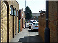
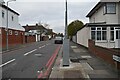
Alley from Cranbrook Road to Pershore Close
The building with the small pediment facing the white vehicles is Pershore Christian Fellowship.
Image: © Robin Webster
Taken: 9 Apr 2011
0.15 miles
5
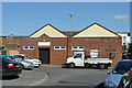
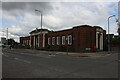
Pershore Christian Fellowship
On Pershore Close.
Image: © Robin Webster
Taken: 9 Apr 2011
0.16 miles
6
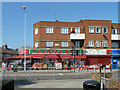
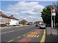
Kashmir Food Store
On the corner of Gantshill Crescent and Cranbrook Raoad.
Image: © Robin Webster
Taken: 9 Apr 2011
0.17 miles